The area called, "Downeast Maine," which includes the region around Calais, is littered with hiking trails and coastal beach walks. Today, we picked a hike closer to home -- just about 5.5 miles from downtown Calais. It was the Devil's Head Conservation Area:
"Devil's Head" is a bit of a misnomer. It is a corruption of the phrase, "d'Orville's Head." The French settlers of St. Croix Island in 1604 named this prominent feature along the shores of the St. Croix River after one of their members, Sieur d'Orville, who shared quarters on the island with Samuel Champlain, a member of Dugua's party of discovery that spent an ill-fated winter on St. Croix Island. Perhaps a more appropriate name for the feature might be the Passamaquoddy name, Kwagustchusk, or Dirt Mountain, referring to its steep eroding frontage on the St. Croix River.
We headed out on the Devil's Head Trail, which winds around the mountain. As we hiked, we encountered a number of curiosities, including this tree that had succeeded in growing sideways under the pressure of some object -- perhaps another tree fallen on it -- and then found room to resume its upward growth:
The moss and ferns in this forest reminded us of the Olympic Peninsula rain forest. Everywhere we turned, beautiful, luxurious green moss greeted us:
This trail was marked by blue blazes, and at many points we had to search out the blazes to be sure we stayed on the trail.
We eventually reached a lookout which gave us a view of St. Croix Island (in the left center of this photo) and the waters of the St. Croix Island International Historic Site, which we visited the other day:
Continuing on our upward spiral around the mountain, we reached another lookout, which gave us a view of Waweig, New Brunswick, across the St. Croix River -- easily visible on this very clear day:
Our first 1.5 miles brought us to the bluffs overlooking a rocky beach. We paused to have a small lunch and enjoyed yet another view of New Brunswick across the river:
After lunch, it was time to climb down some huge granite stairs to the beach to try our hand at hunting for sea glass. These stairs mark the location of an old resort hotel that was constructed in 1889 by eleven Calais residents at this spot. The Demonts Hotel, named after the leader of the 1604 French settlement on St. Croix Island, operated until it burned in the 1920's.
We were not so much interested in resort hotels or their ruins, but started our sojourn along the rocky beach to look for sea glass:
The rocky beach stretches for almost a quarter mile south along the St. Croix River, and we scored every square inch of it looking for glassy treasure:
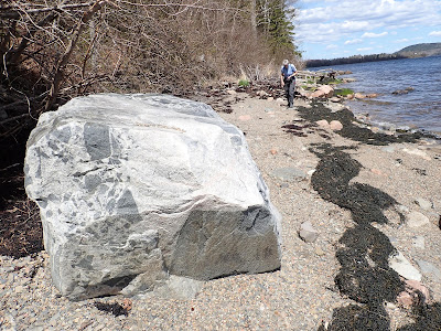
The geology of this area is actually quite interesting, due to its origins with the ancient Appalachian mountain chain, its submersion under Ice Age ice sheets, its scouring, and its inundation by ocean and river waters. Everywhere we walked along the beach, stones large and small gave silent witness to this dramatic geologic history:
Geology or not, the sea glass expedition was successful, as you can see from this photo of the booty Kathy hauled up from the beach:
Having exhausted our archaeological efforts, we decided to hike back along the 1.2 mile Shoreline Bluffs Trail, making a very strangely shaped lollipop for our hiking route. This trail was graced with some interesting man-made features, including some log stairs that David perched on, Karate-Kid-style --
-- and some catawampus signs that Kathy took to heart:
Eventually, the trail wound its way through hillside streams and wetlands, mossy and ferny in their Spring glory, including across some solid log bridges --
-- back to our access road, where we hiked the half mile back to our Jeep.
We're home now, and plotting our adventures for the next 3 days, which promise to have good weather. You can join us out there shortly.


No comments:
Post a Comment
Note: Only a member of this blog may post a comment.