Search This Blog

Monday, February 28, 2022

Beach Walk on South Hutchinson Island

 Monday, February 28, 2022

Hi Blog!

After a couple days of paddling and hanging out with our friends enjoying live music on the waterfront, it was time to take our legs out for a good stretch. We set our sights on a long beach walk on Hutchinson Island. The beach is just a short drive over the south causeway from our campground.

Hutchinson Island is a barrier island in the middle of the Treasure Coast of Florida, stretching a narrow 23 miles through both St. Lucie and Martin Counties with the Atlantic Ocean on the east and the Indian River on the west.

We parked at Jetty Park, located on the north edge of South Hutchinson Island next to the Fort Pierce Inlet. The postcard frame says it all!

The Fort Pierce Jetty is a local hotspot for fishing, especially in the early mornings. Fishermen are known to catch anything from snook to jack crevalle, to sheepshead, snapper, ladyfish and more. The pelicans also seem to enjoy fishing from the jetty. They like the social aspect of it.


The Great White Heron prefers to hunt solo.


The jetty was paved almost the whole length with benches on each side. However, near the end of the jetty there was storm damage and much of the paved surface had washed away.  There were a number of cracks and crevices in the rock creating interesting tide pools.


This was a far as we dared go. The Phillies cap Kathy was wearing started a number of conversations with ex-pats from the Philly and South Jersey area.


In 1995 the U.S. Army Corps of Engineers modified the Fort Pierce Harbor and enlarged the entrance channel to 30 feet by 400 feet and dredged the turning basin to a depth of 28 feet. We saw several large freighters in the harbor.

The north side of Hutchinson Island seemed to get more wave action. We saw a number of surfers at Fort Pierce Inlet State Park. 


We tried several times to get a photo of the shy plovers. As we approached, they ducked behind the rocks. We just happened to catch this little one between hops.


In this photo, the beach looks fairly flat. We were wondering where all the people went. It wasn't until we walked toward the water that we realized our part of the beach was five feet higher than the ocean's edge.


We found a number of broken sand dollars. The insides were filled with nooks and cranies.


We couldn't have picked a better day to walk on the beach. The sky was blue, the sun warm and the breeze gentle.


The waves broke right at the shore line in one long crashing crescendo. They would crash behind us and race by and continue to crash in front of us. Click the link if you would like to watch the blue-green waves crashing onto the beach.

Anyone who knows us, knew there would be some shell collecting. Kathy stated she was going to wait until the walk back to pick up shells. You all know that only lasted about five minutes. Today's hunting and gathering was all about the scallop shells. Someday you will see these shells in a wind chime on the porch of our forever-and-ever house.


Any visit to a touristy beach area would not be complete without a waterfront lunch, complete with pelicans flying by and dolphins swimming around the green island at the end of the marina.

And so ends a great beachy adventure. The chance for rain increases tomorrow, so we are hoping to visit a museum and enjoy some indoor entertainment. Stay tuned.

Saturday, February 26, 2022

Paddling Fort Pierce Inlet State Recreation Area

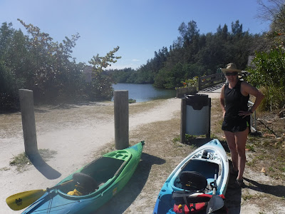
Today was a repair day in Fort Pierce, Florida.  The molding on the lower front edge of our driver-side slide-out had popped out (cheap screws sheared off), and we had to reattach and secure the molding.  This has happened before, unfortunately, so we're experienced at this particular repair, and it only took a couple hours.  This left us the whole afternoon to play.  We had a day off from our friends in Stuart, so we decided to paddle our kayaks again, even after having paddled just yesterday.

A little research told us that the Fort Pierce Inlet State Recreation Area, just across the North Causeway from us, should be an interesting paddle, so we drove the 2 miles or so over to put into the inlet.  Here is a map of part of the recreation area, showing our paddling route from North Causeway Island Park:


Our entire paddle was less than 4 miles, but it took us through a variety of water environments:  up through the Spoil Islands, across into Snapper Cut, down and up into St. Lucie Cut, and then back across the Inlet to the shoreline and return to our point of embarcation.

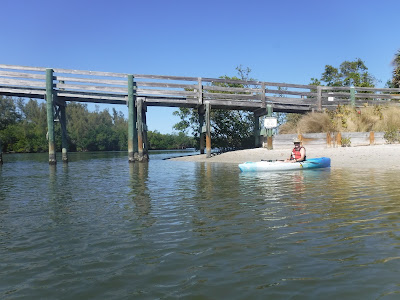
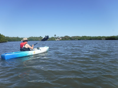
Where we launched was just next to the main Inlet channel, and, waiting to cross the channel with its heavy boat traffic made us think of standing on an Interstate highway and getting ready to race across to the other side.  Here, Kathy braces herself for the paddle across the busy channel:

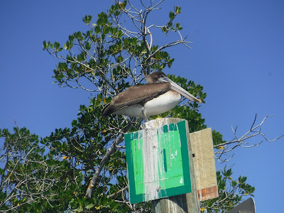
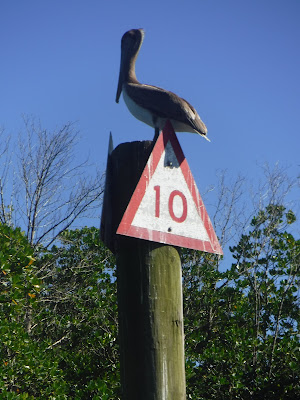
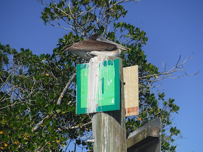
We made it safely across and, reaching the first Spoil Island, we happened upon a perching area for local pelicans -- there were so many that we couldn't count them!

The Spoil Islands in the Fort Pierce Inlet area are among 137 spoil islands formed in the Indian River Lagoon from 1953 to 1961 when the U.S. Army Corps of Engineers dredged the Intracoastal Waterway — the main channel through the center of the lagoon. The Corps left behind heaps of sand on either side of the channel.   Although federal government created the islands, the channel and surrounding spoil islands have become the state's responsibility, with oversight from the Florida Inland Navigation District. The district manages the channel through 11 coastal counties, including St. Lucie County, where we paddled.  The state owns most of the spoil islands, although about a dozen are owned by private or other government interests.  The lagoon's islands teem with exotic plants, including trees with shallow roots that provide little erosion protection and collapse during storms.  The islands were created as an unintended consequence of digging the Intracoastal Waterway. As the waterway was dredged, the "spoil" was dumped along its edge forming a string of islands. Seventy-one of these islands have been designated recreational islands, open to the public for day use and primitive camping.

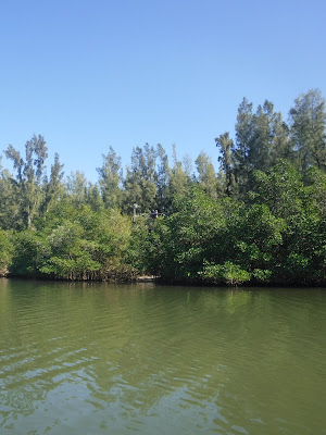
Today, to paddlers such as us, the islands appear nearly natural, with lush mangrove forests covering them:


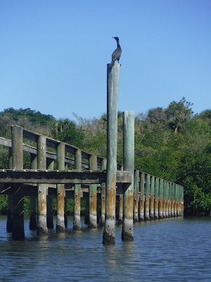
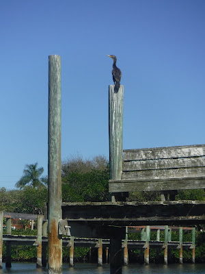
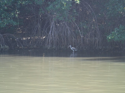
Wading birds and other waterfowl teem in the waters, challenging us to catch photos of all of them:

As we paddled from one Spoil Island to the next, we looked closely at the tangled root systems of the mangroves, noting deposits on them that reminded us of lichen or salt deposits.  But then, even among the harsh colors of these deposits and the brown-gray of the roots, strange, colorful plant life appears:

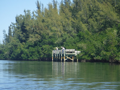
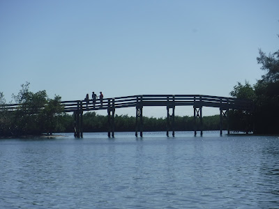
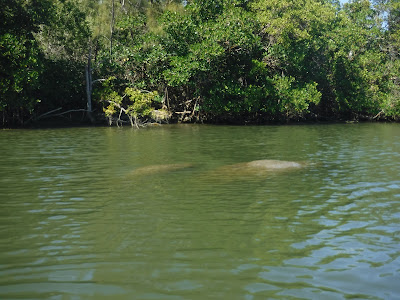
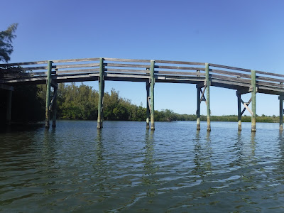
After checking out 4 or 5 of the Spoil Islands, we paddled up Snapper Cut, which is said to be home to manatees.  However, today we did not see any of those mythical mermaid creatures.  We did spy the infrastructure work for roads on Jack Island:

The manatees are not scarce because of lack of protection.  Signs along the waterway enjoin boaters to move slowly in order to avoid disturbing or harming those slow, friendly creatures:

The Great Blue Heron is probably the most shy of the wading birds; they always flee as soon as they are aware that we approach in our kayaks.  Nevertheless, we occasionally surprise them and get close enough to snap a photo as the temperamental bird flees:

For whatever reason, this heron was sure that, by standing on a sandbar in the middle of the lagoon, he/she was safe from our approach.  S/he let us get close enough for a real portrait:

Kathy spotted what looked like a grounded boat in St. Lucie Cut as we were paddling far across the lagoon in the Spoil Islands.  When we got over to the Cut, we had a chance to examine it more closely.  It appeared to have been abandoned for more than one season, with encrustations and dirt piling up on it.  It had been stripped of its motor and most other equipment, although, inexplicably, two valuable winches were still attached to the deck:

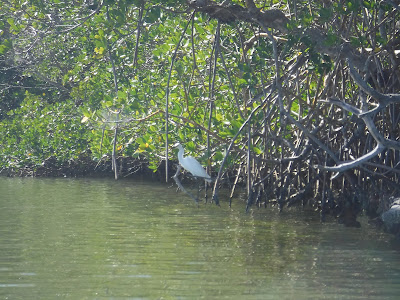
And then there was a pretty egret who let us take her portrait:

Crossing St. Lucie Cut and back across the Fort Pierce Inlet Channel required us to cross the busy lanes of boat traffic using the channels.  This was not for the faint of heart.  We made the crossings safely enough, but as we returned to the shoreline and paddled down to our put-in, we were forced near the channel by the very shallow waters along the shore.  For some reason, the boaters in the Inlet Channel enjoyed passing at full speed, and we "enjoyed" the high waves of their wakes.  Each of us was splashed in turn, and, while we got drenched, the water felt refreshing in the hot Florida sun.

We made it back to our launch site without injury or shipwreck.  Interestingly, as we were loading our kayaks, a St. Lucie County Sheriff cruised up and parked by us to watch us load.  We weren't sure the reason -- perhaps the officer thought we had parked illegally, or perhaps the officer wasn't sure we were loading in the right spot.  But, in any event, as we finished loading, the officer moved on, apparently satisfied that we and our activities were harmless.

We finished the afternoon stopping by a kayak shop in nearby Vero Beach to purchase extra pads for our kayak seats, to help out sitz bones survive long paddles in somewhat greater comfort in the future.

Afterward, it was home and dinner, a phone conversation with our daughter, and plans for an outing of arts and music with our friends again in Stuart.

Nighty-night!


Friday, February 25, 2022

Paddling Round Island near Fort Pierce, FL

Friday, February 25, 2022

Hi Blog!

After taking care of business this morning, we took our kayaks over to Round Island Riverside Park. This Indian River County Park includes a paved parking lot, two boat ramps, canoe launch, picnic pavilion, and a 400 foot boardwalk to observe the manatees - all for free! 


Since we got a late start, we actually met several groups coming back from their paddles. They told us there were manatees in some of the coves. We set out to track down the elusive manatee.


We found a brown pelican perched on channel marker No. 1. Oh wait, that's channel marker No. 11.


As we paddled around the different islands, we came upon the lower observation deck. The folks were disappointed the water was so cloudy that they were not able to see any manatees.


The folks in the high observation platform could see further, but they still didn't spot any manatees.


We pretty much had given up finding any manatees and decided to just paddle around and enjoy the beautiful blue skies and balmy breezes.


As we rounded a small island, we noticed the bridge where we launched our kayaks. There was a family on top pointing to the far right corner of the cove.


As we made our way around, we saw a little snowy egret.


Just past the egret was a disturbance in the surface of the cove. It looked like a turtle or perhaps a palm frond. Having never kayaked with manatees before, we weren't sure exactly what they looked like in the water. Dave carefully approached because it is illegal to bother them. Sure enough, it was a mother and her calf.


The calf slowly sunk down as Dave approached, but the mom stayed calm.  As Dave stopped his kayak, the calf slowly rose back to the surface.  Not wanting to bother the madonna and her offspring, we carefully paddled away and continued our exploration of the small islands around Round Island. There are a few private lots next to the the park. Each property had their own dock. The only ones using the docks were a pair of cormorants.

Here is right cormorant:


Here is left cormorant:


Here is a really cool photo looking under the dock.


While we didn't see as many birds as we have on other paddles, we were constantly entertained by the dancing and jumping mullets as they leaped out of the water to escape capture. 

Just as we were returning to the launch area, we spotted this immature ibis fishing in the shadow of the mangroves.


The Brown Pelican is a comically elegant bird with an oversized bill, sinuous neck, and big, dark body. Squadrons glide above the surf along southern and western coasts, rising and falling in a graceful echo of the waves. They feed by plunge-diving from high up, using the force of impact to stun small fish before scooping them up. This one is taking a rest from his stunning labors on channel marker No. 10.


Returning toward our launch site, we were surprised to see No. 11 still occupied by the exact same brown pellican in the exact same position.


The fishing pier still had a few hopeful fisherman.


The bridge leading to the observation towers allows hikers to look down on the manatees.

We only had time for a two mile paddle, but we were able to get in and around several coves. At one point, we were completely surrounded by jumping mullet. While we couldn't actually see the sting rays, we were pretty sure we disturbed a couple as we entered a shallow cove. From the sandy cloud and strong wake they left, we knew we disturbed something big. It was a beautiful day to be out on the water.

Tomorrow, we have some repairs to do on the RV, but hope to get out and enjoy the Stuart Arts Festival this weekend. Stay tuned.

Cycling Loxahatchee River Battlefield Park

Thursday, February 24, 2022 was our first full day visiting our friends Nan and George Finlayson and Nancy and Jim Tidball where they winter in Stuart, Florida.   A bike ride in Loxahatchee River Battlefield Park in nearby Jupiter, Florida was our first big outing.

The Loxahatchee River Battlefield Park, contained in what is also known as Riverbend Park, is the site of the last great battle of the Second Seminole War. This 64 acre park is one of the most significant multi-level historic sites in Palm Beach County. Prehistoric and historic habitation has occurred along the Loxahatchee for over 5,000 years. The primary goal of the park is to preserve and protect these historic and cultural resources, while providing education and recreation opportunities to the public. 

As soon as the United States acquired Florida in 1821, it began urging the Seminole Indians there to leave their lands and relocate along with other southeastern tribes to Indian Territory (present-day Oklahoma). Some Seminole leaders signed a treaty in 1832, and part of the tribe moved. But other Seminoles refused to recognize the treaty and fled into the Florida Everglades. When the U.S. Army arrived in 1835 to enforce the treaty, the Indians were ready for war. The campaigns of the Second Seminole War involved intense guerrilla warfare by the Seminole. Lasting seven years, it was the fiercest war waged by the U.S. government against American Indians. The United States spent more than $20 million fighting the Seminoles. The war left more than 1,500 soldiers and uncounted American civilians dead. And the obvious duplicity of the U.S. government's tactics marred Indian-white relations throughout the country for future generations.  After the Battle of the Loxahatchee, General Jesup, who commanded the U.S. troops, petitioned Washington to allow the Seminoles to remain in the Everglades and end the war. Washington denied Jesup’s request, whereby six hundred Seminoles were captured under a white flag of truce at Fort Jupiter.

We were ignorant of all this history as we started our pedalling, but we looked forward to the sights and understanding that our fearless leader George would expose us to as we followed him along the multiuse trails in the park:


This is the closest we have every come to duplicating the experience of paddling wetlands and streams while actually riding our bikes.  The wildlife was abundant, including an alligator and many wading birds such as these two:


Our route featured the Loxahatchee River, some smaller streams, and at least two picturesque lakes such as this --


-- and this --


-- as well as a pretty canal over which our bike path stretched:


Our intrepid cyclists posed for a portrait on the bridge --


-- and Kathy and George demonstrated how to bicycle out onto a smaller nearby bridge marked with a sign, "No Admittance - Authorized Personnel Only":


The more law-abiding bikers found some whole shells to mine in gravel and shell fill the park used to build up the path to the canal bridge.  Here, Kathy and Nan display their prizes --


-- while Nance displays some gorgeous spiral shells which may be transformed into a mobile or wind chime:


Pedaling through the canopied hammock forest, we came upon a number of surprises, such as this strawberry made in mosaic out of shells and bezels:


George led us to the 300 year old oak tree, dubbed "Tree of Tears", which sits atop a burial mound, and may have been the place where wounded Seminoles were brought to be treated or buried after the Battle of Loxahatchee.  It and the burial mound are protected by a fence and its history memoralized by a bronze plaque:


Nan then led us to a slightly more whimsical tree.  Can you find the three ladies hiding out in this photo?


Biking on, we crossed a number of additional streams --


-- as we searched for the Park's historic farmstead, which eluded us on this trip.  However, we found some beautiful epiphytes, or air plants, tucked into strategic spots in some of the trees:


The Park is huge, and so, although the parking lots were full of visitors' cars, we only ran into others occasionally, including a few people who launched canoes and kayaks to paddle the streams:


Giving up on our farmstead quest, we started our return ride to our parking lot -- when, suddenly, we encountered this deer who, startling on the trail, bounded into the nearby cover.  We thought she was long gone and we would not get a photo, but it turned out that she only ran far enough to feel protected, and was actually keeping an eye on us.  When we spotted her again in the bushes, she was kind enough to pause long enough for us to snap this portrait:

Cycling builds up a powerful hunger and thirst. After loading the bikes, we drove over to Guanabanas in Jupiter for a lovely lunch on their deck.  So, after an afternoon's outing, we agreed to rejoin for dinner at a local music venue, Terra Fermatta, with carry out food from nearby Taco Shack.  We enjoyed more than two hours of blues presented by Hurricane Hawk and the Invaders.  It was 9:30 when we finally wrapped things up, said our goodnights to our friends, and returned to our campground for a good night's sleep.  

Got to rest to do it again tomorrow!