
Wednesday, September 28, 2016
Monday, September 26, 2016
Balloons and Friends in Mancos
When we decided to stay in Cortez, Colorado, we had our eyes on Canyonlands National Park. By the time we arrived in Cortez, we realized that Canyonlands was too far away to visit comfortably in a day's side trip. On the other hand, we discovered that Mesa Verde National Park was only seven miles from our campground, so we were excited to visit that park, which is so spectacular in its preservation of unique cliffside pueblos. (See our last blog entry to learn about Mesa Verde.)
But the surprise of Mesa Verde was only a prelude to even more exciting news: Dave Lopushinsky and Leslie Manion, ballooning friends from British Columbia, posted on Facebook that they were attending a balloon fiesta in nearby Mancos and that our Alaskan friends Duane and Jean Mathes, whom we had met at the Albuquerque Balloon Fiesta in 2015 were also attending the festival with them!
Never ones to turn down an offer to crew on a hot air balloon, we joined them Saturday morning to help launch Dave and Leslie's balloon, "Pi." When we arrived at the park, it was dark, but as we started laying out the balloon envelope, dawn crept over the park, and Kathy paused to enjoy the rosy colors:

We soon turned to our labors in inflating the balloon. One of our tasks was to hold open the throat of the balloon while Leslie directed a fan to begin the inflation with cold air. David and Jean really seem to be enjoying this part of the job!

Soon, we had the balloon inflated. Pilot Dave Lopushinsky, in the yellow cap, finished his preparations as our trusty crew lent their weight to holding down the bucking balloon:

At our pilot's and crew chief's signals, the balloon rose away, and we had a chance to see Pi in all its glory:

While Dave Lopushinsky piloted Pi to a graceful landing on a nearby farm, Leslie, Duane and Jean drove the rest of us as chase crew to reach the balloon and help secure it. Young people from nearby homes rushed over to help, and with their assistance, Dave and Leslie's pilot friend Dawnna had the balloon envelope in its bag and well under control:

Many balloon pilots have a tradition of hosting a tailgate party back at the launch field, to honor their passengers and crew. Here, Leslie (on the left) and Marilyn, Dawnna's crew chief (on the right) show how a celebration spread should be presented:

On this Saturday, our honored guests were Ella and Henry, who took their first balloon ride with Dave and Pi. Henry had surprised Ella with the balloon ride as a birthday present, and you can see how pleased she was at his thoughtfulness:

Sunday was the second day of balloon flights at the Mancos festival, and Pi launched early. Further, the festival balloons - perhaps 11 or 12 of them - were all able to launch within seconds of each other, so we had the pleasure and excitement of seeing them all rise into the morning sky at the same time:

Kathy snapped this close-up photo of Pi with compatriots in the background:

Transported by the same gentle winds, Pi and its fellow balloons drifted lazily over the farmlands south of Mancos, headed toward successful landings:

Here is a view of Pi as it drifted down past the trees toward its resting place on a farm field, the morning sun lighting up its transluscent envelope from behind:

On this Sunday morning, Charles and Tom, two brothers, were Pi's honored guests. Back at the traditional tailgate party, pilot Dave, on the right, and crew chief Leslie, to the left just behind Chuck, toasted their guests. Dawnna added her huzzah in the background:

Having had two successful days of flights, all of the festival participants returned to the city park in Mancos at sunset to celebrate with an evening glow. In a glow, the hot air balloons inflate until they are upright in the sky, but they do not rise up off the ground. Festival visitors are treated to the sounds of many dragons breathing fire as the pilots fired their burners to light up and heat the air inside their balloons to keep them afloat.
Here, Pi gives us its warm, glowy, evening greeting, complete with fire from the burners reflecting light off the pilot and crew:

All in all, it was a successful and joyous weekend celebration. We drove back to our campground in Cortez, tired but grateful that we had had a chance to join our good friends for a weekend of work and celebration. Our next stop is Albuquerque and its Balloon Fiesta. While Albuquerque's event is much larger, we'll remember the Mancos festival for its intimate, personal, friendly atmosphere.
But the surprise of Mesa Verde was only a prelude to even more exciting news: Dave Lopushinsky and Leslie Manion, ballooning friends from British Columbia, posted on Facebook that they were attending a balloon fiesta in nearby Mancos and that our Alaskan friends Duane and Jean Mathes, whom we had met at the Albuquerque Balloon Fiesta in 2015 were also attending the festival with them!
Never ones to turn down an offer to crew on a hot air balloon, we joined them Saturday morning to help launch Dave and Leslie's balloon, "Pi." When we arrived at the park, it was dark, but as we started laying out the balloon envelope, dawn crept over the park, and Kathy paused to enjoy the rosy colors:

We soon turned to our labors in inflating the balloon. One of our tasks was to hold open the throat of the balloon while Leslie directed a fan to begin the inflation with cold air. David and Jean really seem to be enjoying this part of the job!


At our pilot's and crew chief's signals, the balloon rose away, and we had a chance to see Pi in all its glory:

While Dave Lopushinsky piloted Pi to a graceful landing on a nearby farm, Leslie, Duane and Jean drove the rest of us as chase crew to reach the balloon and help secure it. Young people from nearby homes rushed over to help, and with their assistance, Dave and Leslie's pilot friend Dawnna had the balloon envelope in its bag and well under control:

Many balloon pilots have a tradition of hosting a tailgate party back at the launch field, to honor their passengers and crew. Here, Leslie (on the left) and Marilyn, Dawnna's crew chief (on the right) show how a celebration spread should be presented:

On this Saturday, our honored guests were Ella and Henry, who took their first balloon ride with Dave and Pi. Henry had surprised Ella with the balloon ride as a birthday present, and you can see how pleased she was at his thoughtfulness:

Sunday was the second day of balloon flights at the Mancos festival, and Pi launched early. Further, the festival balloons - perhaps 11 or 12 of them - were all able to launch within seconds of each other, so we had the pleasure and excitement of seeing them all rise into the morning sky at the same time:

Kathy snapped this close-up photo of Pi with compatriots in the background:

Transported by the same gentle winds, Pi and its fellow balloons drifted lazily over the farmlands south of Mancos, headed toward successful landings:

Here is a view of Pi as it drifted down past the trees toward its resting place on a farm field, the morning sun lighting up its transluscent envelope from behind:

On this Sunday morning, Charles and Tom, two brothers, were Pi's honored guests. Back at the traditional tailgate party, pilot Dave, on the right, and crew chief Leslie, to the left just behind Chuck, toasted their guests. Dawnna added her huzzah in the background:

Having had two successful days of flights, all of the festival participants returned to the city park in Mancos at sunset to celebrate with an evening glow. In a glow, the hot air balloons inflate until they are upright in the sky, but they do not rise up off the ground. Festival visitors are treated to the sounds of many dragons breathing fire as the pilots fired their burners to light up and heat the air inside their balloons to keep them afloat.
Here, Pi gives us its warm, glowy, evening greeting, complete with fire from the burners reflecting light off the pilot and crew:

All in all, it was a successful and joyous weekend celebration. We drove back to our campground in Cortez, tired but grateful that we had had a chance to join our good friends for a weekend of work and celebration. Our next stop is Albuquerque and its Balloon Fiesta. While Albuquerque's event is much larger, we'll remember the Mancos festival for its intimate, personal, friendly atmosphere.
Saturday, September 24, 2016
Mesa Verde National Park
Hi Blog!
We arrived in Cortez, Colorado on Tuesday, September 20, 2016, just in time to meet our friends, Duane and Jean, for Happy Hour and Thai food. On Wednesday, we had a long list of chores to get done in anticipation of the Albuquerque Balloon Fiesta. That said, we also wanted to get out and explore the area. Our campground was just seven miles from Mesa Verde National Park. We made a quick visit to the Visitor's Center to gather maps and information and then went to wash Great White who was looking more gray than white after our trip to Alaska.
We had learned from our Boomer/Balloon friends, Dave and Leslie, that Mancos, Colorado was hosting a Balloon and Art Festival this weekend. Mancos is just a 20 minutes drive east from Cortez. Duane and Jean planned to crew for them and would also be staying in Mancos. What a bonus! They invited us to join in the fun.
On Thursday, the whole balloon gang came to Cortez for lunch and we made plans to meet up with them again on Saturday to help. After lunch, it was back to chores!
The weather on Friday, September 23, 2016, was looking a little iffy for a balloon launch, so we chose Friday as our day in Mesa Verde National Park. We had already booked tickets for two tours, but with all the rain and wind Friday morning, we stopped again at the Visitor's Center and exchanged our 10:00 a.m. tour ticket for a 2:00 p.m. tour. We then drove the 20 miles into the park to Chapin Mesa.
Our first stop was the Chapin Mesa Archeological Museum. We learned that Mesa Verde National Park is a World Heritage Site. It protects some of the best preserved Ancestral Puebloan archaeological sites in the United States. With more than 4,300 sites, including 600 cliff dwellings, it is the largest archaeological preserve in the U.S. Just outside of the museum we got our first glimpse of one of the cliff dwellings. Spruce Tree House was closed due to rock fall, so this is as close as we got.

There are two loop roads on top of the mesa. Our first tour was the Balcony House located on the Cliff Palace Loop. As we walked back to our truck from Spruce Tree House, the weather began to lift. Here we got our first look at Soda Canyon.

Balcony House is set on a high ledge facing east overlooking Soda Canyon. Its 45 rooms and 2 kivas would have been cold during the winter. We had to climb a 32 foot ladder to get in. Here Kathy demonstrates her ladder skills.

As if climbing a 32 foot ladder wasn't challenging enough, we then had to crawl through a 12 foot tunnel and up another ladder and through a tiny, square, stone porthole. Here Dave shouts encouragement as Kathy's hips were snuggly wedged inside the narrow tunnel.


Ranger Larry, who led our hike through Balcony House, had lots of great information to share. For example, the earliest construction was the most exacting. Later construction was a little haphazard, as if done quickly. Once we knew what to look for, it was easy to see all the additions made to the original structures. Ranger Larry gave us a real window into what life must have been like for the Ancestral Pueblo people and why they built in this location and constructed their pueblos as they did.

All of the cliff dwellings have one or more kivas, which are subterranean rooms used for religious ceremonies. The kivas resemble the pit homes of yet earlier ancestors, and people theorize that many of the ceremonies were familial- or clan-based and looked back toward practices of their ancestors. Mesa Verde-style kivas included a feature from earlier times called a sipapu, which is a hole dug in the north of the chamber that is thought to represent the Ancestral Puebloans' place of emergence from the underworld. In the photo below, the large hole in the center is a fire pit and the small hole is the sipapu.

It is not clear why the Ancestral Puebloans left their established homes in the late 13th century or early 14th century. We discussed with Ranger Larry a number of factors, including climate change, prolonged periods of drought, topsoil erosion, environmental degradation, deforestation, hostility from new arrivals, religious change and infighting over scarce resources. But it seemed pretty obvious from the way this entrance was bricked up leaving only a small passageway that the residents were afraid of someone getting in.

As if squeezing out wasn't bad enough, we then had to scale the cliff face to reach the mesa above. Lucky for us, the Park Service put up a chain link fence along the very, very narrow toe holds.

In case you were wondering, this was the view from the so-called stairway!

After reaching the top, we high-fived Ranger Larry and drove over to Cliff Palace for our next tour. Cliff Palace it thought to be the largest cliff dwelling in North America. It contains 23 kivas and 150 rooms and had a population of approximately 100 people. Because of the large number of kivas, it is thought that Cliff Palace was a social, administrative site with high ceremonial usage. It certainly is impressive when you see it from afar.

As we got closer, we felt dwarfed by the large tower structures. Ranger Patrick covered a few of the same topics as Ranger Larry, but it was not repetitive. We probably would have enjoyed the Cliff Palace tour better if it was not so crowded.

One of the towers still has some of its original plaster inside. As we looked up, we could see a number of original paintings.

We finished our tour with another exciting climb up and over the ledge of the canyon. No photos this time, if you've seen one scary cliff climb photo, you've seen them all.
On the ride back down the park road, we stopped at the Mancos Valley overlook to catch some of the fall color on the flanks of Silver Mountain and its sister peaks.

As with so many of our stops, we wish we had more time to explore. There were several hiking trails and petroglyph trails that we'll have to leave for next time. Until then, stay thirsty my friends.
We arrived in Cortez, Colorado on Tuesday, September 20, 2016, just in time to meet our friends, Duane and Jean, for Happy Hour and Thai food. On Wednesday, we had a long list of chores to get done in anticipation of the Albuquerque Balloon Fiesta. That said, we also wanted to get out and explore the area. Our campground was just seven miles from Mesa Verde National Park. We made a quick visit to the Visitor's Center to gather maps and information and then went to wash Great White who was looking more gray than white after our trip to Alaska.
We had learned from our Boomer/Balloon friends, Dave and Leslie, that Mancos, Colorado was hosting a Balloon and Art Festival this weekend. Mancos is just a 20 minutes drive east from Cortez. Duane and Jean planned to crew for them and would also be staying in Mancos. What a bonus! They invited us to join in the fun.
On Thursday, the whole balloon gang came to Cortez for lunch and we made plans to meet up with them again on Saturday to help. After lunch, it was back to chores!
The weather on Friday, September 23, 2016, was looking a little iffy for a balloon launch, so we chose Friday as our day in Mesa Verde National Park. We had already booked tickets for two tours, but with all the rain and wind Friday morning, we stopped again at the Visitor's Center and exchanged our 10:00 a.m. tour ticket for a 2:00 p.m. tour. We then drove the 20 miles into the park to Chapin Mesa.
Our first stop was the Chapin Mesa Archeological Museum. We learned that Mesa Verde National Park is a World Heritage Site. It protects some of the best preserved Ancestral Puebloan archaeological sites in the United States. With more than 4,300 sites, including 600 cliff dwellings, it is the largest archaeological preserve in the U.S. Just outside of the museum we got our first glimpse of one of the cliff dwellings. Spruce Tree House was closed due to rock fall, so this is as close as we got.

There are two loop roads on top of the mesa. Our first tour was the Balcony House located on the Cliff Palace Loop. As we walked back to our truck from Spruce Tree House, the weather began to lift. Here we got our first look at Soda Canyon.

Balcony House is set on a high ledge facing east overlooking Soda Canyon. Its 45 rooms and 2 kivas would have been cold during the winter. We had to climb a 32 foot ladder to get in. Here Kathy demonstrates her ladder skills.

As if climbing a 32 foot ladder wasn't challenging enough, we then had to crawl through a 12 foot tunnel and up another ladder and through a tiny, square, stone porthole. Here Dave shouts encouragement as Kathy's hips were snuggly wedged inside the narrow tunnel.

Here we get our first look at the balcony that Balcony House was named for. While no one really knows for sure why this cliff dwelling has walls along its balcony, many scientist believe it was a defensive fortification.

Ranger Larry, who led our hike through Balcony House, had lots of great information to share. For example, the earliest construction was the most exacting. Later construction was a little haphazard, as if done quickly. Once we knew what to look for, it was easy to see all the additions made to the original structures. Ranger Larry gave us a real window into what life must have been like for the Ancestral Pueblo people and why they built in this location and constructed their pueblos as they did.

All of the cliff dwellings have one or more kivas, which are subterranean rooms used for religious ceremonies. The kivas resemble the pit homes of yet earlier ancestors, and people theorize that many of the ceremonies were familial- or clan-based and looked back toward practices of their ancestors. Mesa Verde-style kivas included a feature from earlier times called a sipapu, which is a hole dug in the north of the chamber that is thought to represent the Ancestral Puebloans' place of emergence from the underworld. In the photo below, the large hole in the center is a fire pit and the small hole is the sipapu.

It is not clear why the Ancestral Puebloans left their established homes in the late 13th century or early 14th century. We discussed with Ranger Larry a number of factors, including climate change, prolonged periods of drought, topsoil erosion, environmental degradation, deforestation, hostility from new arrivals, religious change and infighting over scarce resources. But it seemed pretty obvious from the way this entrance was bricked up leaving only a small passageway that the residents were afraid of someone getting in.

As if squeezing out wasn't bad enough, we then had to scale the cliff face to reach the mesa above. Lucky for us, the Park Service put up a chain link fence along the very, very narrow toe holds.

In case you were wondering, this was the view from the so-called stairway!

After reaching the top, we high-fived Ranger Larry and drove over to Cliff Palace for our next tour. Cliff Palace it thought to be the largest cliff dwelling in North America. It contains 23 kivas and 150 rooms and had a population of approximately 100 people. Because of the large number of kivas, it is thought that Cliff Palace was a social, administrative site with high ceremonial usage. It certainly is impressive when you see it from afar.

As we got closer, we felt dwarfed by the large tower structures. Ranger Patrick covered a few of the same topics as Ranger Larry, but it was not repetitive. We probably would have enjoyed the Cliff Palace tour better if it was not so crowded.

One of the towers still has some of its original plaster inside. As we looked up, we could see a number of original paintings.

We finished our tour with another exciting climb up and over the ledge of the canyon. No photos this time, if you've seen one scary cliff climb photo, you've seen them all.
On the ride back down the park road, we stopped at the Mancos Valley overlook to catch some of the fall color on the flanks of Silver Mountain and its sister peaks.

As with so many of our stops, we wish we had more time to explore. There were several hiking trails and petroglyph trails that we'll have to leave for next time. Until then, stay thirsty my friends.
Wednesday, September 21, 2016

Monday, September 19, 2016
Colorado National Monument: Monument Canyon - Wedding Canyon Loop Hike
Colorado National Monument, established on May 24, 1911, contains spectacular canyons cut deep into sandstone, granite–gneiss–schist, rock formations, and extensive areas of igneous rock. It is an area of desert land high on the Colorado Plateau, with pinion and juniper forests. It hosts a wide range of wildlife, including red-tailed hawks, golden eagles, ravens, jays, desert bighorn sheep, and coyotes. Standing on the canyon rim, you can identify over 1.5 billion years of geologic history in nine distinct rock formations that remain neatly arranged by age.
Monument Canyon is the feature attraction of Colorado National Monument. The canyon contains two striking formations, Independence Monument and the Kissing Couple, and a formation known as the Coke Ovens.
We had only today to hike in the park, and we decided the big canyon had to be our playground, so we started up the Monument Canyon Trail:

The canyon provides immense vistas and wide varieties of rock formations, including this sandstone mass that was heaved up at an angle some unnumbered eons ago:

Yet, in addition to beauty on a grand scale, the park also provides brilliant colors on a small scale in the early Fall:

After nearly 2 miles of hiking, we rounded the corner of a cliff and got our first clear view of Independence Monument:

The park's tallest freestanding tower at 450 feet high, the tower is featured in the cultural history of the park, in that the park's first caretaker, John Otto, who explored the area and built some of the trails, was the first known person to climb it, raising a U.S. flag atop its flat summit on Independence Day in 1911.
We couldn't get too distracted by the tower itself, however, because at every turn we found rocks and formations that were unique and fascinating:

Huge cliffs and spires loomed over us as we worked our way further up the canyon:

We eventually reached the base of Independence Monument, finding that it looks completely different from every vantage point:

Here is another view of the monument - one that is more famous because it is the view of the tower that most people see from Rimrock Drive:

Otto’s route in his famous climb up Independence Monument is one of the most popular rock climbs in western Colorado. On almost any day, climbers can be seen scaling its cracks and chimneys by grabbing the empty holes left by pipes Otto sunk in the sandstone for his climbs. Otto's pipes have long since been removed for safety reasons, because they did not remain secure, but the route remains. Every July 4, climbers ascend the tower in celebration of his original feat - a popular local event.
As we were hiking, we heard some voices from above. We looked up, and, to our amazement, spotted two climbers just as they were completing their climb of the tower:


Wedding Canyon doesn't have the huge vistas that Monument Canyon has, but it continued to surprise us with a variety of terrains and interesting rock formations. Here, David finds a potential route under some leaning boulders:

Looking down Wedding Canyon, we could see the Colorado River and the cities of Grand Junction and Fruita in the distance:

Kathy found a little rock cairn perched on a boulder and couldn't resist adding her own little quartz buddy to the pile:

Once we reached the bottom of the canyon, we turned eastward toward our trailhead, but still had several ridges to cross before we reached our ultimate goal. Some of the ridges were unique formations of tilted sandstone, pocked with circular hollows that could only have been made by rocks and boulders being slung against the stone by rushing water:

Here's an up-close look at one of these formations:

This was a very hot hike, with the temperature rising to 91F before we finished. We always carry plenty of water, but this was one of the few hikes we've taken where we've actually drunk all four liters of water we carried. We were grateful to return to the truck and a cool bottle of Gatorade to quench our thirst and replenish some electrolytes. We drove home, tired but very satisfied with the hike we had chosen today - a chance to put our boots on the ground and really get to know Colorado National Monument.
Monument Canyon is the feature attraction of Colorado National Monument. The canyon contains two striking formations, Independence Monument and the Kissing Couple, and a formation known as the Coke Ovens.
We had only today to hike in the park, and we decided the big canyon had to be our playground, so we started up the Monument Canyon Trail:

The canyon provides immense vistas and wide varieties of rock formations, including this sandstone mass that was heaved up at an angle some unnumbered eons ago:

Yet, in addition to beauty on a grand scale, the park also provides brilliant colors on a small scale in the early Fall:

After nearly 2 miles of hiking, we rounded the corner of a cliff and got our first clear view of Independence Monument:

The park's tallest freestanding tower at 450 feet high, the tower is featured in the cultural history of the park, in that the park's first caretaker, John Otto, who explored the area and built some of the trails, was the first known person to climb it, raising a U.S. flag atop its flat summit on Independence Day in 1911.
We couldn't get too distracted by the tower itself, however, because at every turn we found rocks and formations that were unique and fascinating:

Huge cliffs and spires loomed over us as we worked our way further up the canyon:

We eventually reached the base of Independence Monument, finding that it looks completely different from every vantage point:

Here is another view of the monument - one that is more famous because it is the view of the tower that most people see from Rimrock Drive:

Otto’s route in his famous climb up Independence Monument is one of the most popular rock climbs in western Colorado. On almost any day, climbers can be seen scaling its cracks and chimneys by grabbing the empty holes left by pipes Otto sunk in the sandstone for his climbs. Otto's pipes have long since been removed for safety reasons, because they did not remain secure, but the route remains. Every July 4, climbers ascend the tower in celebration of his original feat - a popular local event.
As we were hiking, we heard some voices from above. We looked up, and, to our amazement, spotted two climbers just as they were completing their climb of the tower:

Again, however, we had to turn our eyes to the path because we had further to hike. Our ultimate goal was the Kissing Couple, a rock formation given that name because it resembles just that:

We couldn't help trying to duplicate this little pose:

Kissing Couple isn't the only feature of this hike with romantic implications. Independence Monument is also known as the site where John Otto wed a young woman who, once she discovered his idiosyncracies, quickly left him. An alternate route to Independence Monument is known as Wedding Canyon in honor of his ill-fated wedding. We decided to hike back down to our original trailhead through Wedding Canyon, which provided its own, unique views of Independence Monument, on the left in this photo:

Wedding Canyon doesn't have the huge vistas that Monument Canyon has, but it continued to surprise us with a variety of terrains and interesting rock formations. Here, David finds a potential route under some leaning boulders:

Looking down Wedding Canyon, we could see the Colorado River and the cities of Grand Junction and Fruita in the distance:

Kathy found a little rock cairn perched on a boulder and couldn't resist adding her own little quartz buddy to the pile:

Once we reached the bottom of the canyon, we turned eastward toward our trailhead, but still had several ridges to cross before we reached our ultimate goal. Some of the ridges were unique formations of tilted sandstone, pocked with circular hollows that could only have been made by rocks and boulders being slung against the stone by rushing water:

Here's an up-close look at one of these formations:

This was a very hot hike, with the temperature rising to 91F before we finished. We always carry plenty of water, but this was one of the few hikes we've taken where we've actually drunk all four liters of water we carried. We were grateful to return to the truck and a cool bottle of Gatorade to quench our thirst and replenish some electrolytes. We drove home, tired but very satisfied with the hike we had chosen today - a chance to put our boots on the ground and really get to know Colorado National Monument.
Sunday, September 18, 2016
Arches NP - Hike to Morning Glory Bridge
Hi Blog!
Today was our day to scout out Arches National Park in Utah. We are currently parked in Grand Junction, Colorado. It is about a two hour drive from here to Arches. We would have liked to camp closer to the park, but we are working our way south to Albuquerque for the Balloon Fiesta. We know we will be back in this area next year, so we wanted to gather as much information as we could while we were here. We also wanted to get in a hike and see an arch or two.
We headed West on I-70 and then south on US 191. It wasn't long after leaving the interstate that the red rock formations began to appear and so did the traffic. This is definitely the longest park entrance line we've been in this year.

Surprisingly, there were still plenty of parking places at the Visitor Center. We arrived just in time to watch a great park video on the formation of the arches. After chatting with a park ranger and getting all sorts of ideas for hikes, we decided to have lunch before heading off to the trailhead. This was the view from our picnic table.

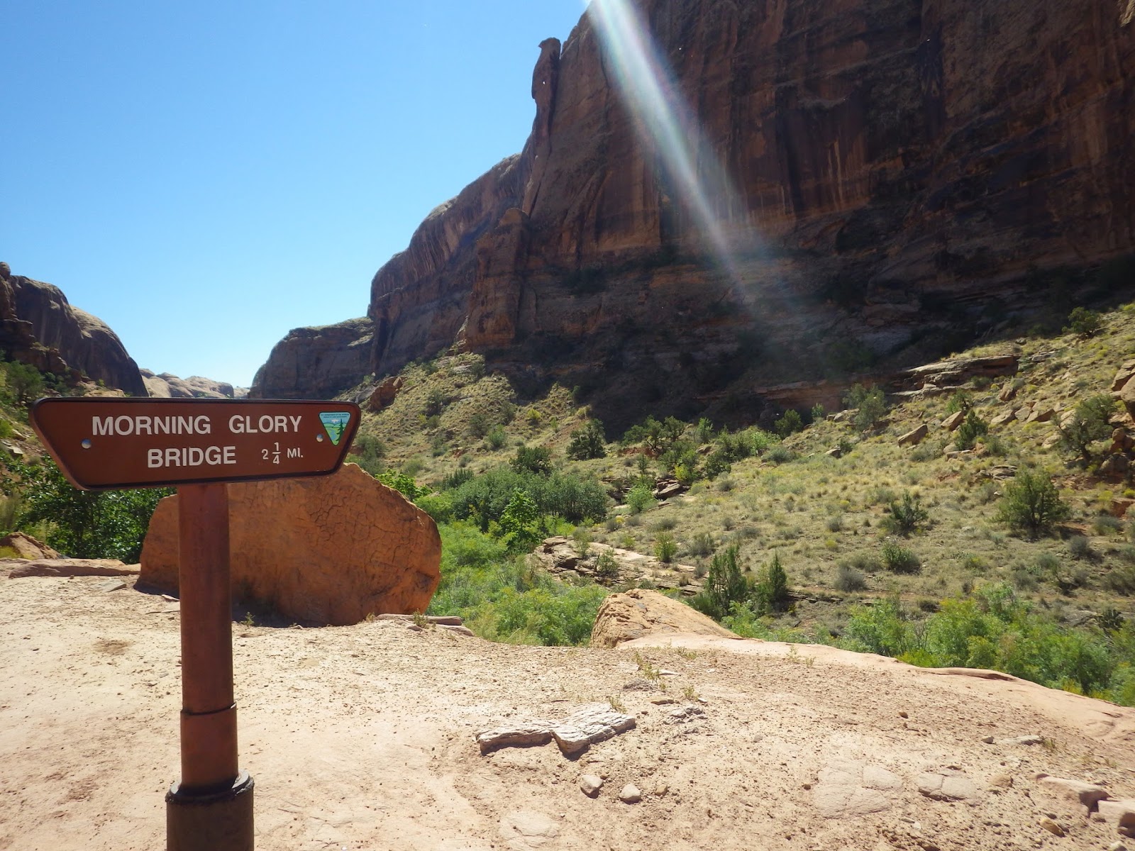
After poring over maps and trail descriptions and considering the massive amount of vehicles coming into the park, we decided to hike to the Morning Glory Natural Bridge located just six miles outside the park entrance on BLM land. Our friends, Beverly and Alan Tackman, had recently done this hike and raved about it. When we arrived at the trailhead parking lot and found enough room to park Great White, we were doubly glad we picked this hike.

We followed the trail up Negro Bill Canyon which was named after William Granstaff, a black prospector and rancher who grazed his cattle here during the late 1800s. A perennial stream winds its way down toward the Colorado River providing green shady areas.

The trail is laid out before us as we work our way up the canyon.

As we looked back down the canyon, the trailhead parking lot had disappeared.

The Navajo Sandstone towers above us.

We cross the stream over and over again.

We soon leave the stream behind and follow the trail up a steep slope into a side canyon. At the end of the canyon, we get our first glimpse of Morning Glory Natural Bridge.

Morning Glory is the sixth largest natural bridge in the United States. It's span is 243 feet. Now you may be wondering what the difference is between an arch and a natural bridge. Well, a natural bridge is an arch formed by a current of water, such as a stream.

Here Kathy stands next to a very tiny trickle of water coming right out of the canyon wall. It's hard to believe that this tiny seep once flowed so forcefully that it created this natural bridge.

We met another couple at the trails end that asked us to take their photo. Turns out, they were married hanging under the natural bridge. They apparently climbed up and rapelled halfway down, hanging in midair, where the preacher performed the ceremony dangling from a climbing harness. They come back every year to celebrate their wedding anniversary. They were kind enough to take our photo reflected in the pool under the bridge.

The arch is so large, it was difficult to get it all in one frame. Here Kathy stands under the natural bridge for scale.

Having reached the end of the road, it was time to turn back down the canyon. We had still managed to find a few things we missed on the way up, like this really cool round rock island.

We also noticed this arch in waiting. Just think, in a few thousand years there may be another arch in this canyon.

After finishing our hike, we decided to take Utah State Route 128 back to the interstate. The entire length of the highway has been designated the Upper Colorado River Scenic Byway. SR128 begins just north of Moab and follows the southern bank of the Colorado River through a narrow, steep gorge, described as spectacular by National Geographic. We would have to agree with that description as we found it one of the most scenic drives we have taken to date. We look forward to coming back next year and exploring more of this area.
Today was our day to scout out Arches National Park in Utah. We are currently parked in Grand Junction, Colorado. It is about a two hour drive from here to Arches. We would have liked to camp closer to the park, but we are working our way south to Albuquerque for the Balloon Fiesta. We know we will be back in this area next year, so we wanted to gather as much information as we could while we were here. We also wanted to get in a hike and see an arch or two.
We headed West on I-70 and then south on US 191. It wasn't long after leaving the interstate that the red rock formations began to appear and so did the traffic. This is definitely the longest park entrance line we've been in this year.

Surprisingly, there were still plenty of parking places at the Visitor Center. We arrived just in time to watch a great park video on the formation of the arches. After chatting with a park ranger and getting all sorts of ideas for hikes, we decided to have lunch before heading off to the trailhead. This was the view from our picnic table.

After poring over maps and trail descriptions and considering the massive amount of vehicles coming into the park, we decided to hike to the Morning Glory Natural Bridge located just six miles outside the park entrance on BLM land. Our friends, Beverly and Alan Tackman, had recently done this hike and raved about it. When we arrived at the trailhead parking lot and found enough room to park Great White, we were doubly glad we picked this hike.
We followed the trail up Negro Bill Canyon which was named after William Granstaff, a black prospector and rancher who grazed his cattle here during the late 1800s. A perennial stream winds its way down toward the Colorado River providing green shady areas.

The trail is laid out before us as we work our way up the canyon.

As we looked back down the canyon, the trailhead parking lot had disappeared.

The Navajo Sandstone towers above us.

We cross the stream over and over again.

We soon leave the stream behind and follow the trail up a steep slope into a side canyon. At the end of the canyon, we get our first glimpse of Morning Glory Natural Bridge.

Morning Glory is the sixth largest natural bridge in the United States. It's span is 243 feet. Now you may be wondering what the difference is between an arch and a natural bridge. Well, a natural bridge is an arch formed by a current of water, such as a stream.

Here Kathy stands next to a very tiny trickle of water coming right out of the canyon wall. It's hard to believe that this tiny seep once flowed so forcefully that it created this natural bridge.

We met another couple at the trails end that asked us to take their photo. Turns out, they were married hanging under the natural bridge. They apparently climbed up and rapelled halfway down, hanging in midair, where the preacher performed the ceremony dangling from a climbing harness. They come back every year to celebrate their wedding anniversary. They were kind enough to take our photo reflected in the pool under the bridge.

The arch is so large, it was difficult to get it all in one frame. Here Kathy stands under the natural bridge for scale.

Having reached the end of the road, it was time to turn back down the canyon. We had still managed to find a few things we missed on the way up, like this really cool round rock island.

We also noticed this arch in waiting. Just think, in a few thousand years there may be another arch in this canyon.

After finishing our hike, we decided to take Utah State Route 128 back to the interstate. The entire length of the highway has been designated the Upper Colorado River Scenic Byway. SR128 begins just north of Moab and follows the southern bank of the Colorado River through a narrow, steep gorge, described as spectacular by National Geographic. We would have to agree with that description as we found it one of the most scenic drives we have taken to date. We look forward to coming back next year and exploring more of this area.
Subscribe to:
Posts (Atom)