Search This Blog

Friday, October 29, 2021

Long Point Trail at Summersville Lake

Friday, October 29, 2021

Hi Blog!

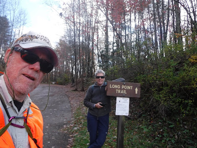
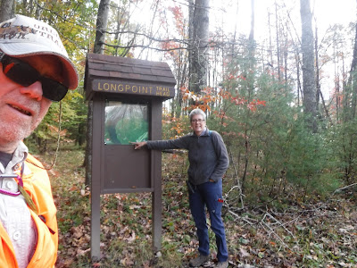
We did a lot of driving yesterday in order to get in our visit to New River National Park before "stormageddon" hit us. We just beat the rain, which poured on us all night and into the morning. After lunch today, the skies cleared and we had a little time to explore some more. However, we had covered most of the New River National Park that was close to us. The other visitor centers were more than an hour and a half drive away. Rather than endure three more hours of driving, we decided to find something closer to camp. Just 12 miles from camp was the trailhead for the Long Point Trail, which promised views of Summersville Lake


Summersville Lake is West Virginia’s largest lake. It has over 2,800 acres of water and 60 miles of shoreline.  Boating, water-skiing, swimming, fishing for large and smallmouth bass, walleye, panfish, and catfish, (trout are stocked below the dam in the spring and fall) scuba diving, picnicking, hunting, hiking and biking are the favorite activities enjoyed by nearly one million visitors annually. 

We are here!


Summersville Lake is formed by the rock-fill Summersville Dam on the Gauley River, south of Summersville in Nicholas County, West Virginia. Its maximum depth is 327 feet.  The lake was constructed between 1960 and 1966 by the United States Army Corps of Engineers in order to control flooding in an 803-square-mile watershed along the Gauley River and the Kanawha River. At 390 feet tall, 2,280 feet long, and containing 12,000,000 cubic yards of dirt and rock, the dam itself is the second-largest rock-fill dam in the Eastern United States. President Lyndon B. Johnson dedicated both the dam and a new Summersville Post Office on September 3, 1966.


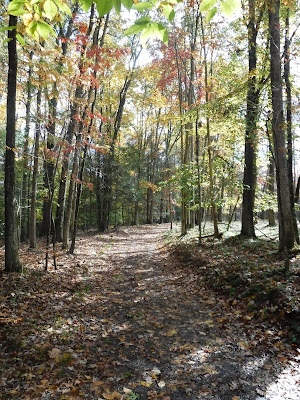
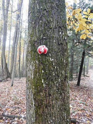
 The trail took us through a classic Appalachian hardwood forest, home to one of the most diverse collections of birds in North America. The trail is well marked, even if some of the blazes are upside down!


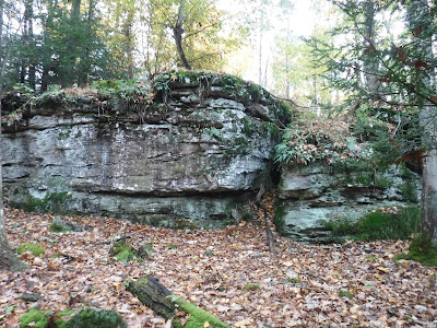
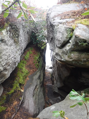
We stopped to admire this hanging garden:


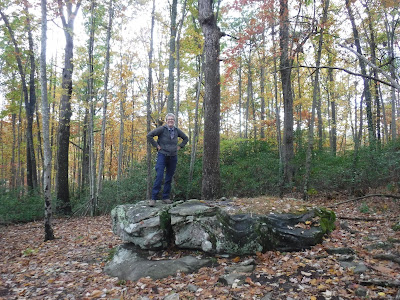
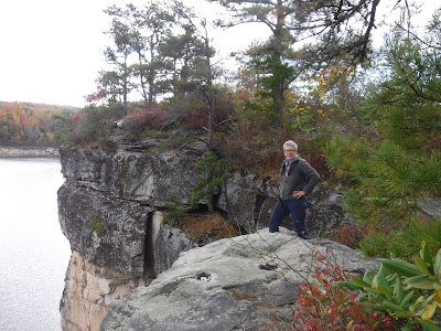
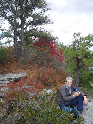
Dave asked Kathy to pose on this rock. However, it was too wet to lie down in any type of seductive pose.  (Dave was very disappointed....)


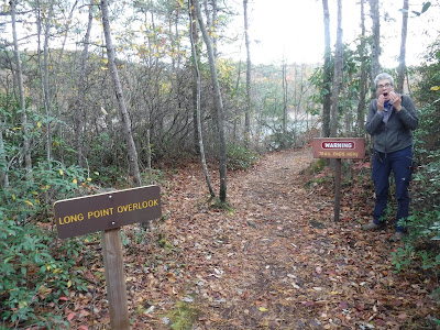
The Army Corps of Engineers wanted to make sure we knew the Trail Ends Here! Of course, that didn't stop us from venturing out onto the the rocky overlook.


The sandstone cliffs are impressive.


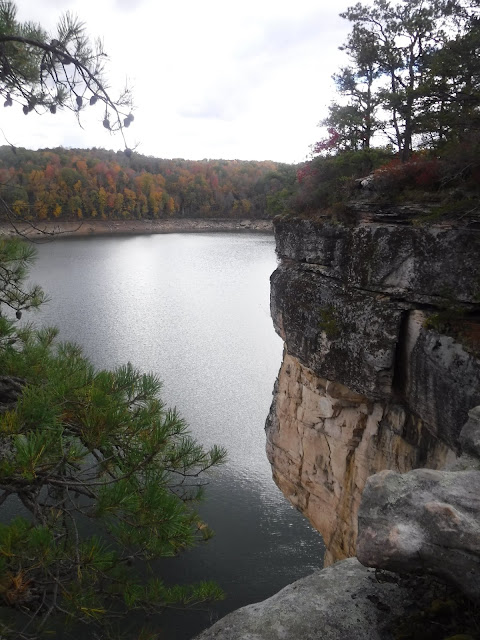
Don't jump! Some of the cliffs at Summersville Lake range from anywhere between 40 and 60 feet high. People were injured after jumping off a 52 foot high cliff. It is now illegal to jump off the cliffs.


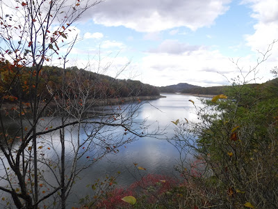
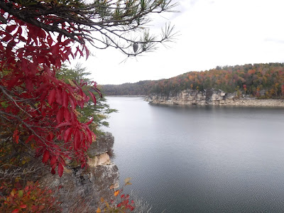
We were treated to three different views of the lake as it wrapped around Longpoint:


While Dave was busy taking photos, Kathy sat far back from the precipitous ledge.


Water finds a way.


There are over 25 different trees that call this part of West Virginia home. They apparently left all of their leaves on our trail.


 More rain is expect tonight and tomorrow so this may be our last post from Summersville. Stay tuned; after a short visit to see William for Halloween, we head to Tennessee!

Thursday, October 28, 2021

New River Gorge and the Endless Wall Trail

Well, here we are in Summersville, West Virginia.  We are staying in a campground on a cliff overlooking Summersville Lake, and under the shadow of the Summersville Lake Lighthouse:

Weather will not be our friend at this stay; a huge storm is hitting us as we write this blog entry.  We knew that we would only have today to get out on foot to explore the nearby New River Gorge National Park and Preserve.

After breakfast and the morning kitty walk, we drove to a nearby CVS to get our booster Covid shots, then hightailed it to the national park visitor center to learn as much as we could about the park before picking a trail to hike:


The visitor center is a stone, modern-design building with clean lines that reminds us of the stony cliffs of the New River Gorge:


The visitor center gave us an opportunity to learn about the geologic and human history of the gorge, which was carved, possibly 300 million years ago.  In this sense, the New River is anything but new. Dating back to the days of the supercontinent Pangaea, it is one of the oldest rivers in the world and one of the few waterways in North America that runs north.  The New River was born when the North American and African plates collided to form the supercontinent Pangaea. The impact uplifted the Appalachian Mountains to Himalayan heights, and a mighty river named the Teays formed to drain the western slopes of the range. From its headwaters in what is now western North Carolina, the Teays flowed north through the Virginias before turning west into the Ohio River Basin, eventually draining into a vast inland sea.  Today the New River begins in the same headwaters carved by the Teays and follows roughly the same northward path.  Around 60 million years ago, the diagonally trending ridges of the Appalachians went through a period of uplift, but the highly erosive Teays kept cutting into the mountains faster than the uplift rate. Thus, the river’s south-to-north course runs counter to the west-to-east flow of most Appalachian waterways, carving a formidable 400-meter-deep river canyon directly through the Appalachian Plateau.

Here, in southern West Virginia, a road was cut in the late 1800's down into the gorge, a bridge constructed over the river, and a road cut up the other side.  It met the tracks of a railroad along the river, helping to transport coal from 3-foot seams in the cliffs above the New River to various markets around the country.  Eventually, however, time passed this area by.  The coal mines closed, and the bridge was condemned.  In 1977, a new, spectacular bridge was constructed in its place: 


The present bridge is a steel arch bridge 3,030 feet long, supported by an arch 1,700 feet long.  It was the world's longest single-span arch bridge for 26 years.  It spans the gorge 876 feet above the New River, making the bridge one of the highest vehicular bridges in the world; it is the third highest in the United States. Because of its height, the bridge has attracted daredevils since its construction. It is now the centerpiece of the annual "Bridge Day", during which hundreds of people, with appropriate equipment, are permitted to climb on or jump from the bridge. In 2005, the structure gained additional attention when the US Mint issued the West Virginia state quarter with the bridge depicted on one side. In 2013, the bridge was listed on the National Register of Historic Places.

We had a view of the bridge from an observation platform near the visitor center, where David also got pictures of the New River itself as it plowed through its gorge:


Here is a closer view of the river, showing a small vehicular-and-pedstrian bridge that is a replica of the original 1800's bridge:


Referring to park information we got at the visitor center, we decided to use our precious time today to hike the Endless Wall Trail, which, with a half-mile section of road, forms a 3-mile loop trail that took us along the tops of the dramatic, sheer vertical sandstone walls of the gorge.  Here, we started our hike:


As with most national parks, this trail was well-constructed and maintained, including some heavy wooden-beam bridges over the small creek that winds through this section of the park:


Once we got out to the rim, we gained a good view of the sandstone cliffs of the "Endless Wall":


Several viewpoints along the cliff offer dramatic views of the gorge and river:


At Diamond Point, Kathy found a lone tree set bravely out on a cantilevered rock, and decided to join it in the blustery wind:


Nearing the end of our rim walk, we found another viewpoint, where Kathy paused to appreciate a beak-nosed sandstone point on the wall opposite our position:


David wasn't the only one to find solid wooden bridges.  Kathy liked this one and showed it off:


The gorge supports an almost rainforest-type climate, as witnessed by this rare silver fern --


-- and this tree-ear mushroom!  We have never seen either of these before in all of our hikes.


Finishing our hike, we hopped in the Jeep and drove down the old road to the river level in the gorge.  This road is part of the national park and is maintained as part of its attractions.  The road took us over the replica of the original vehicle bridge that was replaced in 1977:


We hopped out of the Jeep, walked out onto the replica bridge, and were treated with this gorgeous view of the new bridge span:


Time was a-wasting.  We needed to get home to give the kittens their afternoon walk.  The storm was approaching.  We were getting hungry.  So we hustled back to our RV to plan another day-long driving tour of this large national park in one of the two rainy days that remain to us here.  Stay tuned!
 

Hiking Upon Mt. Cacapon

Hi Blog!

We are little late in posting our blog entries. During our stay in Great Cacapon, West Virginia, we had limited cell and internet. However, we had an overabundance of beautiful fall foliage and amazing views. On Sunday, October 24th, we drove over to Berkeley Springs to check out the Cacapon Resort State Park. On the way, we stopped at the summit of Prospect Peak where were could look down upon the Potomac River. National Geographic calls Prospect Peak one of the five best scenic views in the East.


As we made our way through Berkeley Springs, we discovered a Sunday Farmer's Market. We picked up an apple dumpling for breakfast on Monday. We also stopped at the Grilled Cheese Truck and picked up sandwiches for lunch.


Berkeley Spring was America's first spa. A fountainhead of warm mineral waters frequented by Native Americans long before Europeans arrived in the New World are at the heart of the community. First noted as Medicine Springs in 1747 on a map drawn by Thomas Jefferson’s father, the waters for many centuries have drawn visitors seeking health and relief from the stress of everyday life. George Washington first visited in 1748 and made the area his favorite getaway through the 1760s.  In 1776, Washington’s family and friends drew up a plat of 134 lots, named the streets, and incorporated The Town of Bath, invoking the muses of the renowned English spa. Yet the magic of the springs prevailed, and the town and surrounding area are known around the world by their name — Berkeley Springs.


After securing our purchases, it was on to the Cacapon "Resort" State Park. Cacapon State Park was constructed by the Civilian Conservation Corps on land that had been clear-cut for its timber in the early 20th century. It officially opened July 1, 1937. Most of the construction of the park took place in the 1940s by CCC workers, with additional construction of cabins and the lodge in the 1950s. The famous Robert Trent Jones golf course was added to the park in 1973, advancing it to the status of a "resort" park.  While we love to golf, we were more interest in the older historic CCC sites. We decided to have our lunch in the Batt Pavilion.


Inside the pavillion, we tucked into our gourmet grilled cheese sandwiches. David enjoyed a mac and cheese grilled cheese, while Kathy enjoyed the Greek with feta and olives.


As delicious as those sandwiches were, they were also incredibly heavy. Not sure that was the best lunch to eat before climbing a mountain, but at least we weren't going to starve on the trail. 

We began our hike on Ziller Loop Trail:


Originally West Virginia was part of a great ocean and, over time, loose sand became sandstone, mud compacted to form shale and calcareous shells became limestone. Evidence of the uplifting and folding is all around. 

We began our climb upon Mt. Cacapon through a deciduous forest.


Cacapon Mountain takes its name from the Cacapon River (from the Native American meaning "medicine water") which empties into the Potomac River near the town of Great Cacapon. While the mountain is only 2,618 feet high, we had a 1,000 foot elevation gain in less than a mile.


There are no photos from our ascent, since we spent the time huffing and puffing. To celebrate reaching the summit, Kathy added a rock to the summit cairn.


The park map indicated there was a scenic overlook at the summit. As hard as we looked, we could not find the view.  A local hiker we encountered confirmed that, in fact, there is no scenic view because of tree growth the entire length of the ridge summit of Mt. Cacapon.


We decided to take the longer and less steep trail back down to the parking lot. We did get a view of the new resort lodge. If a more rustic stay is to your liking, you can still book the Old Inn, which was the original lodge built by the CCC.


Cacapon State Park is in the Ridge and Valley Province that was formed at the end of the Paleozoic Era by the horizontal pressure on the layers of sediment. All of the rocks in this area are sedimentary and it took 300 million years to create, fold and uplift them to their current form. Here Dave demonstrates how to show off your form.


As avid hikers, we have seen all sorts of trail blazes from simple cuts in a tree, to painted blazes in a myriad of colors, painted can lids and plastic circles. In all our hiking, this is the first time we've come across an exclamation point blaze. We wondered what it could mean, until we found ourselves looking down into a holler where the trail went straight down to the bottom.


While this was not our longest hike, we felt we got a good workout and needed a little refreshment when we returned to the trailhead. We made our first stop at Berkeley Spring Brewing. While the outdoor seating area was very nice, the brewery was filled with locals who glared at us for wearing masks when we entered the bar area to order our beers. We quickly quaffed our imperial stout and made our way to our second stop.


Cacapon Mountain Brewing Company was more our style. Located in an old mill building in downtown Berkeley Springs, the tap room was spacious and welcoming and they had several picnic tables outside where we could sip and relax.


We picked three styles to sample. The Fest beer was a standard octoberfest style. The porter was smooth and dark with just the right amount of sweetness. The Saison was light with lots of great belgian yeasty flavors. We couldn't decide which was our favorite, so we brought all three home.


We feel we only just scratched the surface of this area of West Virginia. Our next stop takes us further south in West Virginia to explore the new New River Gorge National Park. Stay tuned!

Bicycling the Chesapeake & Ohio Canal Trail from Paw Paw Tunnel

On Friday, October 22, 2021, we finally had a chance to get outdoors again after a lot of logistics.  Having moved to Gary's Cox Camping in Great Cacapon, in the far northeast hills of West Virginia, we decided to bicycle part of the Chesapeake & Ohio Rail Trail, which was accessible nearby in Paw Paw, West Virginia.  Here we are as we started the trail:


The rail trail has been formalized as the Chesapeake & Ohio Canal National Historic Park.  The Chesapeake and Ohio Canal operated from 1831 to 1924 along the Potomac River between Washington, D.C., and Cumberland, Maryland. It replaced the Potomac Canal, which shut down completely in 1828. The canal's principal cargo was coal from the Allegheny Mountains.  Construction on the 184.5-mile canal began in 1828 and ended in 1850.  It required the construction of 74 canal locks, 11 aqueducts to cross major streams, more than 240 culverts to cross smaller streams, and the 3,118 ft Paw Paw Tunnel. A planned section to the Ohio River at Pittsburgh was never built.

It turns out that our choice of Paw Paw to being our bike ride gave us a chance to explore the Paw Paw Tunnel, which was an important feature of the original canal.  The tunnel was built to bypass the Paw Paw Bends, a six-mile stretch of the Potomac River containing five horseshoe-shaped bends. The town of Paw Paw, the bends, and the tunnel take their name from the pawpaw trees that grow prolifically along nearby ridges.  The tunnel took more than 6 million bricks and 14 years to complete.  The tunnel was used by canal boats until the C&O closed in 1924. The tunnel and towpath are now maintained for public use as part of the Chesapeake and Ohio Canal National Historical Park. Though never one of the longest tunnels in the world, Paw Paw Tunnel remains one of the greatest engineering feats of its day.

It was only a half-mile ride to the tunnel, south-eastward along the canal path.  Even the entrance was impressive:


The tunnel is open to visitors.  Fortunately, the original towpath has been preserved and is a convenient walking path to explore the length of the tunnel without having to wade in the canal waters below:


The photo above gives you some idea of the tunnel's interior personality, but a photo alone is not enough.  In this video, Kathy demonstrates the proper method of hiking through a tunnel, and it captures the "spirit" of the tunnel more completely.

Unfortunately, the downstream end of the tunnel has been closed to bicycles and hikers because of a rockslide at that entrance.  We could walk from the upstream end, through the entire tunnel, but were stopped by fencing when we reached the far end:


Those who are brave enough, including those who want to pedal the entire canal path from Alexandria to Pittsburgh, can push their bicycles up (and down) a detour around the tunnel.  We, however, did not choose to do so, but simply turned upstream and set out on a 10-mile outing on the open bicycle path above the tunnel.

It wasn't long before we encountered what looked like a lock-keeper's residence near the Paw Paw Tunnel.  It now sits next to a picnic area and campground.  The campground is currently closed for the season, but we saw many picnickers in the open field by the historic residence.


The Baltimore & Ohio Railroad constructed a competing route along the Potomac River, right across the canal from the towpath.  As we pedaled further north from Paw Paw, we crossed under an old railroad bridge for that railroad:


The national park unit occupies the canal and railroad rights of way, but, on either side, there are numerous private properties.  It is clear, for example, that the strips of land between the canal and the Potomac River were farmed over the centuries.  Some fields are still farmed, and it appears that one property owner has rented out sections of that strip of land to hunters or fishermen to set up RV camps:


Most of the canal corridor is moist, giving opportunities for lush undergrowth.  It also nurtures a wide variety of fungi that feast on fallen trees:


As we reached our turnaround point, we crossed an old bridge that straddled a drainage for the canal.  It appeared that the bridge embraced doors that could be opened to empty the canal:


The drainage ran down to the Potomac River, and it invited us to follow it down to a gravel beach to see what views the river would provide us:

We decided to hike down to the Potomac River from the canal trail and saw this panorama.

After exploring the river beach, we crossed by foot back under the towpath, through the dry canal, and climbed an embankment up to the abandoned rail line.  We were curious about the condition of the railbed.  While the railbed was distinct and intact for the full length of our ride, sections have become overgrown, presenting obstacles to hikers and bikers who might be adventurous enough to explore the rail line.

We mounted our bikes for the ride back to our trailhead, and, as we rode, we noted a bridge on the far side of the Potomac that we had not seen on our ride out.  Kathy checked her GPS and confirmed that the bridge crosses the Little Cacapon River where it empties into the Potomac River:


We were happy that we had a chance to get out and stretch our legs after a week or so without our most enjoyable outdoor activity.  After another day or so, we hope to find a hike to add spice to this stay!