
While looking forward to stopping at the National Parks and Monuments along the way, the main reason for the drive was to get to the BLM Visitor's Center in Kanab, Utah in time to participate in the lottery drawing for hiking permits for The Wave. Unfortunately, just as the morning mist was burning off to reveal some more amazing scenery, we realized we were going to be an hour late to the lottery, since Utah and Arizona are in different time zones!

With no chance for a permit, we stopped at the Visitor's Center anyway to gather as much information about the hikes offered on BLM lands. We watched an amazing documentary on the Grand-Staircase Escalante. We now have lots of ideas for future outings. In the meantime, back to being tourists. First stop, Kane County Office of Tourism.

The volunteer at the information desk gave us lots more ideas for hikes and activities in the area. He said a trip to Kanab would not be complete without a visit to Moqui Cave - a very unique museum located in a cave five miles up the road.

Moqui Cave was once used by Anasazi people as a shelter or food store, according to archaeological digs in the area. It was rediscovered by white settlers in the 19th century, and served as a speakeasy in the 1920s during Prohibition. In 1951, the cave was purchased by Laura and Garth Chamberlain, who opened a tavern and dance hall the following year, and it became a tourist attraction and museum. Apparently, the bar tender was a real Pittsburgh Steelers fan. While Kathy loves the bar, she gave a thumbs down on the whole Steelers motif.

Moquie Cave was much bigger than we first thought. The museum portion contains a substantial rock collection, including many ultraviolet-fluorescent minerals, fossils, pottery, spear points, American Indian artifacts and art, dinosaur tracks (estimated to be over 140 million years old), and displays about the Anasazi. What's not to like about fluorescent rocks!

After exploring the museum, we headed south and picked up US89A toward the North Rim of the Grand Canyon. A few miles out of Kanab, we see signs for Pipe Spring National Monument. Since neither of us had heard of it, we did a quick check on Google. Pipe Spring was named by the 1858 Latter-day Saint missionary expedition to the Hopi mesas led by Jacob Hamblin. In the 1860s Mormon pioneers from St. George, Utah, led by James M. Whitmore, brought cattle to the area, and a large cattle ranching operation was established. In 1866 the Apache, Navajo and Paiute tribes of the region joined the Utes for the Black Hawk War, and, after they raided Pipe Spring, a protective fort was constructed by 1872 over the main spring. Here's our first look at the fort know as Winsor Castle.

After watching a documentary on the history of Pipe Spring, we went out to meet the Park Ranger for the tour. Turns out, he was the very same Ranger in the documentary. Ranger Benn Pikyavit is a Kaibab Paiute who grew up in the area. His grandmother use to tell him stories of the Mormons. After serving in Vietnam, he came back and became a Park Ranger. As the Park's librarian, he is always on a quest for the truth.

Pipe Spring was named by the 1858 Latter-day Saint missionary expedition to the Hopi mesas led by Jacob Hamblin. In the 1860s Mormon pioneers from St. George, Utah, led by James M. Whitmore brought cattle to the area, and a large cattle ranching operation was established. In 1866 the Apache, Navajo and Paiute tribes of the region joined the Utes for the Black Hawk War, and, after they raided Pipe Spring, a protective fort was constructed by 1872 over the main spring. From this photo, you can see the steps leading down to the spring room.

The Kaibab Paiutes faced starvation and continued struggle to survive after being cutoff from their water supply. The overgrazing by the Mormon cattle reduced their native food. It wasn't until 1933 that an order by the Secretary of the Interior resolved conflicts over water use by dividing the precious stream flow evenly among the Park Service, private cattlemen and the Kaibab Pauites. It is hard to believe something so peaceful and serene could have caused so much conflict.

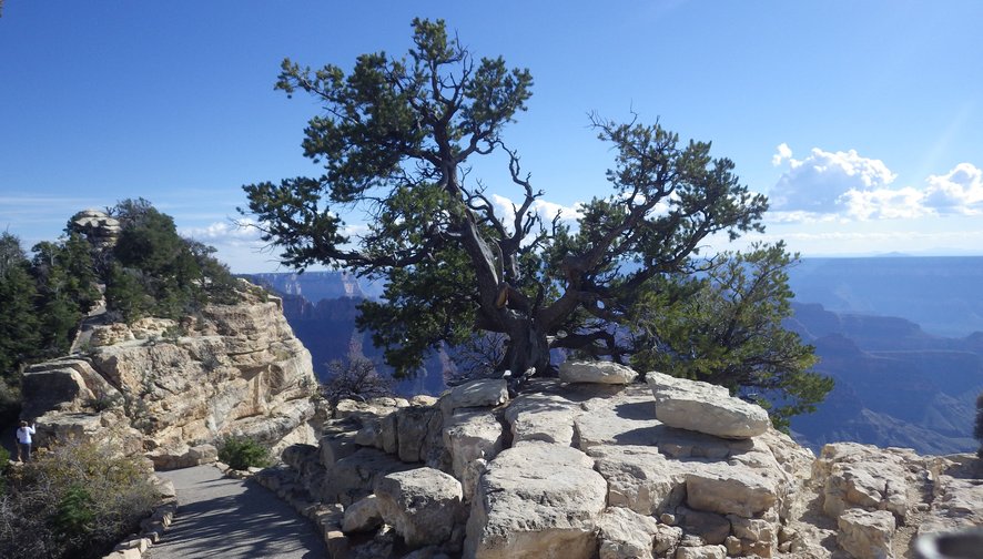
When we left Pipe Spring, we felt like we had a better understand of the huge area we were driving through. Before long, we were heading up, up, up into the Kaibab Forrest. We topped out at 8840 feet above sea level. The North Rim of the Grand Canyon didn't reveal itself until after we parked and walked out to Bright Angel Point. The late afternoon light and the pollution from California made it diffult to photograph, but that didn't lessen our enjoyment.

There is something timeless about the Grand Canyon that makes it difficult to put in words. It is no wonder so many artist spend their entire careers trying to capture the magic of the place.

While this is not our first trip to the Grand Canyon, it is our first visit to the North Rim. It is a much wilder place than the South Rim. Most of the trails around the rim are the original trails sans guard rails!
There are many, many more side canyons on the north side which makes hiking out to the points exciting with views on both side.

We knew it was going to be a short visit. We just really wanted to look down into the canyon since we were going to be driving right by. We made lots of notes and collected maps and brochures for our next visit. We definitely want to hike down to the Cottonwood campground and perhaps even visit Phantom Ranch again!
We retraced our steps back to US89A and turned our attention to the Vermillion Cliffs. The Vermilion Cliffs are the second "step" up in the five-step Grand Staircase of the Colorado Plateau.


The Vermilion Cliffs are made up of deposited silt and desert dunes, cemented by infiltrated carbonates and intensely colored by red iron oxide and other minerals, particularly bluish manganese. With the sun hidden behind the summit, the colors are intense.

We finally get to see the Colorado River! Here is the view from the Navajo Bridge looking down stream into Marble Canyon. Marble Canyon is the section of the Colorado River canyon in northern Arizona from Lee's Ferry to the confluence with the Little Colorado River, which marks the beginning of the Grand Canyon. The name Marble Canyon is a misnomer because there is no marble there. Although Major John Wesley Powell knew this when he named the canyon, he thought the polished limestone looked a lot like marble.

If it wasn't so late in the day, we would have stopped to explore the walking bridge and Lee Ferry area, but we decided to leave that for another day. There is only so much you can do in a day.
Time is the fire in which we burn.
Wow!!! Are you ever on an intensive study of the West. When all is said and done will you garner PHD s in archaeology and western history with the intent of returning as Rangers and Guides?
ReplyDeleteBtW how are you travelling on all those curvy roads?
As you know, we are on a five year mission to seek out new life and new civilizations, to boldly go.... Seriously, we love to explore. The more we learn, the more interesting a place is to us. We often thought about being volunteer rangers, but so far, we've been too busy exploring to stop one place long enough to volunteer. As for the curvy roads, Great White just goes slow. People can pass us if they want. We're not in a hurry. We're retired! :)
Delete