Search This Blog

Friday, March 17, 2023

Eno River State Park

Friday, March 17, 2023 

Hi Blog!

We've made it to our next stop near Four Oaks, North Carolina. We are about an hour away from the Raleigh-Durham area. After moving on Wednesday and logistics on Thursday, we were eager to get out and stretch our legs. We set our sights on the Eno River State Park.

The Park contains more than 4,500 acres of protected natural area that provide vital water quality protection, wildlife habitat, and preservation of historic resources. There are five access areas with over 24 miles of trails offering entry into a largely unspoiled river environment. We started our adventure at the Pleasant Green Access and hiked beginning on the Laurel Bluffs Trail.


Partnering with the Nature Conservancy, the State of North Carolina, the City of Durham, and Durham and Orange Counties, the Eno River Association was able to create the Eno River State Park in 1973.  Since then, the Association has worked tirelessly to expand the Park in order to protect the natural and cultural heritage of the Eno River and to ensure that the public will be able to enjoy it for future generations. One of the Association's projects was adding birdhouses along the trail.


Spring is definitely in the air. The cardinals along the trail were busy courting. This guy stopped to catch his breath before heading back into the fray.


Dave doing his best impression of a cardinal:


Eno River State Park is home to the Parkwood bamboo grove. The Eno River Association hopes to manage the bamboo grove to create a productive and esthetically pleasing public space. A healthy grove of bamboo is uniquely beautiful, is a good habitat for birds, reduces rainwater runoff from surrounding land, and offers a pleasant parkland for walking and contemplation. We contemplated the grove (in the background in the photo below) from the bridge over Euclid Stream.


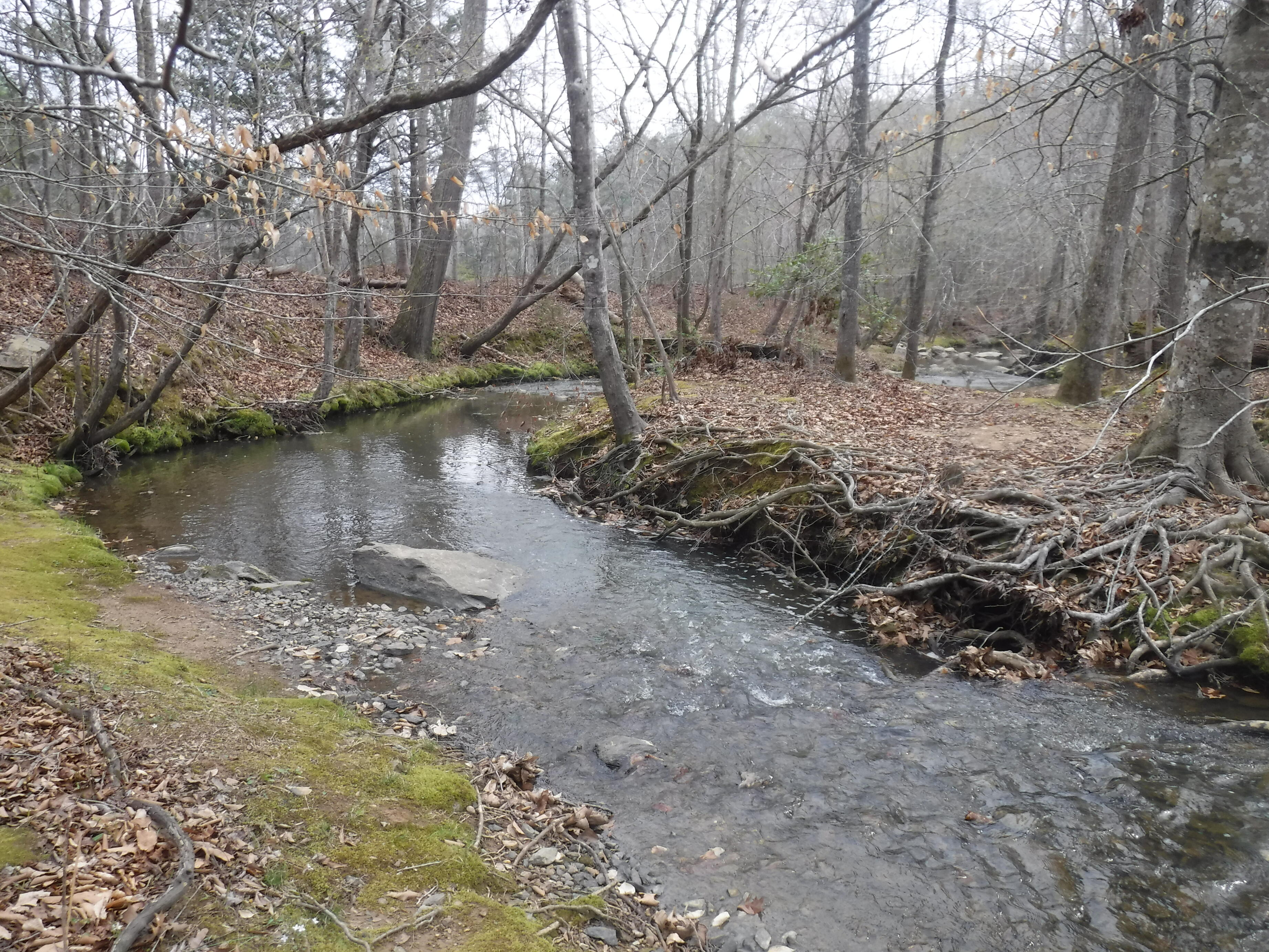
The trail leaves the Laurel Bluffs and comes down the banks of the Eno River. The Eno River, named for the Eno Native Americans who once lived along its banks, is the initial tributary of the Neuse River in North Carolina. Descendants of European immigrants settled along the Eno River in the latter 1740s and early 1750s, including many Quakers from Pennsylvania.


We followed the river downstream until we reached the cut-off for the Eno Quarry Trail. The Eno Quarry was excavated in the 1960s to provide stone for the construction of nearby Interstate 85. When the project was completed, a number of large blue boulders were left behind.


Over time, the quarry filled in naturally with water, and visitors soon followed. The quarry was originally on private property, and locals would trespass to swim, fish, or cliff jump. Today, it is part of the state park. While it is not illegal to swim, there are several rather large signs suggesting it is deep and dangerous. With the recent cold weather, no one was swimming today, although we met one hiker who said that he loves to swim in the quarry during the summers.


We followed a loop trail around the quarry lake.


The top of the quarry is rather boggy.


Rhodes Creek runs right along the edge of the quarry.


In order to continue our journey, we needed to cross the creek.


After circling the quarry, we headed toward the Cabe Lands Trail. The "Cabe" of Cabe Lands refers to Barnaby Cabe who owned the land from before the American Revolution. In 1760, Mr. Cabe purchased 112 acres of land along the Eno River. He managed a gristmill on four thousand acres, and had nine daughters. His two wives predeceased him.

After crossing the Cabe Lands, we decended back toward the banks of the Eno River.


At one point, there were thirty-two different mills along the Eno River. The last mill ceased operations in 1942 when a flood broke the dam across the river. Eventually, the building collapse from old age and neglect in 1973. There are still some foundations and diversion channels cut into the banks. These two fine bridges were an Eagle Scout project that helped us cross a couple diversions.


On our way back to the trailhead, we decided to take another hike around the quarry lake.


A diver recently went to the bottom of the quarry. It was 55 feet down, pitch black and 48 degrees Fahrenheit.


The Eno River is a swift, shallow stream flowing for 33 miles from Orange County to Durham County. It's waters roll through wilderness, passing historic mill sites, river bluffs covered with flowering shrubs, and fords used by early settlers. Here are some of the tiny wildflowers we spotted.


We had a mile left in our hike when the wind began to pick up and the rain they predicted for later this afternoon came early. The last photo we took was of a turtle family on a log.

The rain and cold predicted for this weekend may keep us home. Until the next adventure, stay thirsty my friends.


Saturday, March 11, 2023

Hiking the Weston Lake Loop Trail in Congaree National Park

Congaree National Park is a relatively little-known national park in South Carolina. Some reports show it as the 10th least visited national park in the nation. Certainly when we settled into camp at Santee State Park in South Carolina, we had forgotten all about Congaree National Park and didn't realize it was only a 45 minute drive from where we are camped.  We found it by luck as we searched for a good hike in the area.  Our search turned up the Weston Lake Loop Trail in Congaree and, because it is a national park we hadn't visited, we had no trouble getting excited about trying it!

If it is symbolized by anything, Congaree National Park is symbolized by its champion old-growth trees characteristic of Bottomland Hardwood Forests:

Bottomland hardwood forests are found in broad lowland floodplains along large rivers and lakes. They are occasionally flooded, which builds up the alluvial soils required for the gum, oak and bald cypress trees that typically grow in this type of biome. The trees often develop unique characteristics to allow submergence, including cypress knees and fluted trunks, but cannot survive continuous flooding.  Typical examples of this forest type are found throughout the Gulf Coast states, and along the Mississippi River in the United States, but the bottomland hardwood forest that is home to the tallest old growth pines and cypress trees has been preserved at Congaree National Park.  It is also the largest tract of old growth bottomland hardwood forest left in the United States. 

The park received its official national park designation in 2003 as the culmination of a grassroots campaign that began in 1969.  It has an unique character that is captured in this painting by Stephen Chesley:

We felt that spirit as we stood at the entrance gate to the Boardwalk Trail in the park.  The gate reminded us of gates to Japanese gardens:

It is Spring, and the trees are starting to show their fresh green leaves.  Here, the leaves contrast with the blackened soil of areas of the park where rangers have been conducting prescribed burns to reduce the risk of wildfire:

Spring is now also evident in the yellow-spray patterns of pine pollen on the water above the Dorovan muck.  The boardwalk takes you across dark-colored mud, a mixture of clay and old leaves. This mud, called Dorovan muck, is eight feet thick and plays an important role in the health of the floodplain.  It filters water, traps pollution, and turns pollutants into harmless compounds. By filtering water, it helps keep the floodplain and the associated lakes and rivers clean.

Over the years, Congaree National Park has boasted the tallest known specimens of fifteen different trees, including a 167 foot loblolly pine, which we will discuss later -- the National Champion Loblolly Pine.

"Champion Tree" is a designation afforded to selected trees that are special or superlative because of the combination of their height, size and significance. The designations in the US are recorded in the National Register of Champion Trees, which is a list of the largest tree specimens found in the United States as reported by American Forests to the public. A tree on this list is called a National Champion Tree. Congaree National Park has one of the largest concentrations of champion trees in the United States.

Well, Kathy always loves to hug big trees, but she gave a Champion Hug to this Champion Tree!

Our hike took us around the Boardwalk Trail and then on the Weston Lake Loop Trail, which starts at Weston Lake, a shallow lake formed in a deeper section of the bottomland swamp.  While dramatically different than the surrounding, tree-covered swamp floor, the lake was relatively small and relatively unremarkable.  Although it appeared dirt-laden, it bears an abundance of fish.

The wet areas of bottomlands and swamps in Congaree are typified by large cypress trees and water tupelos, a tree similar to cypress but without the unique "knees" that surround most cypress trees.  In contrast, the higher, drier areas are characterized by loblolly pine, maple, oak and sweet gum.  We are experienced in hiking in higher areas, and we know the usual hazards:  rocks and roots are the chief threats, and we call them Rock Gnomes and Root Gnomes.  These gnomes leap up and try to trip a hiker without warning, and it's important to maintain great vigilance against them.

But today, we discovered a new type of gnome on the trail -- a Knee Gnome!  It is a cypress knee growing up in the middle of the trail where it oughtn't not to be.  They're supposed to only be in the immediate area around a cypress tree -- not by their lonesome looking for trouble on a hiking trail.  In the photo below, Kathy keeps a newly-named Knee Gnome from leaping up into the air:

Having discovered these new gnomes, we stood alert for more as we continued along the trail.  To our surprise, we were treated to a sight that few hikers ever see -- a gnome nursery -- a place where those pesky gnomes, be they Rock Gnomes, Root Gnomes or Knee Gnomes, are born and nurtured until they are mature enough to venture out on the trail by themselves and challenge unwary hikers.  

Here is the first-ever photograph of a Knee Gnome Nursery:

And, you may ask, what happens to gnomes when they get old, perhaps too tired to continue their leaping, tripping ways?  Well, again, we were lucky enough to take an unprecedented photograph of a Senior Knee Gnome who is clearly too tired to rise up and terrorize hikers:

But enough of the dark side of hiking.  Now to the wonderful side.

You recall our discussion of Champion Trees, and that Congaree National Park is home to the National Champion Loblolly Pine.  Well, as it happens, our pre-hike research found a trail guide for the Weston Lake Loop Trail, produced by Friends of the Congaree, which revealed the National Champion Loblolly Pine's true, hidden location and described the route we must take, along an unmarked trail, to find it.

And so we did.  Kathy persuaded the National Champion to have his photo taken with her, and he obliged.  He was, however, unwilling to give us an autograph.

These Champion Trees are larger than you can imagine.  A hugging picture can help you understand their girth.  A pose with Kathy and the National Champion can help you imagine their height.  But to truly understand their size, you must get deeper into the subject.  And so Kathy did.  She was so deep that the camera could barely pick out her smiling face at the other end of this hollowed-out, fallen giant:

This one might be a champion, but we're not sure of what.  Perhaps of telling scary monster stories to those baby cypress knees sitting in the swampy muck at his (ahem) knee:

And if monster champion trees weren't enough, we came across a "Walking Maple."  According to that trail guide from the Friends of the Congaree, a winged red maple seed landed on a tupelo or cypress stump years ago, and extended its roots over and through the old tree stump. The stump eventually rotted away, leaving only the maple trunk and its pedestal roots.  Who would have thought?

Our trail eventually brought us around to Cedar Creek, which is deep enough for paddling canoes or kayaks -- although the Park Service warned in the Visitor Center that, due to a large number of fallen trees in the creek, numerous portages are required and that, therefore, Cedar Creek is not suitable for any but the most expert paddlers:

We saw no animals in our visit, other than a couple of squirrels.  There were, however, some flora that graced the trail.  The first we saw was this unusual and interesting fungus growing on the trunk of a recently fallen tree:

Here, some beautiful, golden-colored wildflowers have thrived in the protection of another fallen tree:

These beautiful little paw paw flowers showed us all their stages of development as, we guess, the paw paw trees were starting to strut their Spring stuff:

This blossom had fallen to the trail, and seems to be from a plant common in bottomland hardwood forests, because people have found them in Louisiana's Chicot State Park, but we were not able to find its name.  That didn't impair its beauty, though:

We have visited other swamps -- notably Okefenokee and Everglades -- but we've never visited a Bottomland Hardwood Forest swamp, nor learned as much as we did on this visit about cypress, water tupelo, walking maple, and, of course, those grand Champion Trees!

May our next adventure be as bountiful.


Friday, March 10, 2023

Santee NWR Cuddo Unit

Thursday, March 9, 2023 

Hi Blog!

We left coastal Georgia and are now in the sandhill region of South Carolina. We are camped in Santee State Park on the banks of Lake Marion. We had last visited this area in March 2022 with hopes of paddling the Plantation Island Canoe Trail in the Cuddo Unit of Santee National Wildlife Refuge. As we mentioned in our 2022 blog, we were unable to visit the Cuddo Unit because it is closed on Mondays. For a full report of what happened last time, click the link to our 2022 blog. While we really enjoyed our last visit, we did make plans to visit again and make sure it wasn't on a Monday!

Thursday morning dawned bright, clear and chilly. We set off for the Santee NWR Visitor Center to double check access and get updated maps. As it turns out, the Visitor Center was closed due to a lack of volunteers. They did however, provided maps in the kiosk in the parking lot. With map in hand, we took off to the trail head. 


The main road around the Cuddo Unit is a one-way wildlife drive. It travels through various habitats - mixed hardwoods, mixed pine, bottomland hardwoods, cypress, marsh, old fields and ponds. We saw several egrets and herons along the way.


It always amazes us when we visit a large park like this and have the place to ourselves.


Well, not exactly to ourselves. We do have to share the trail with large alligators.


After setting our kayaks out, we went down to the water's edge to see what we could see.


Yes, Virginia, there was a large alligator near the launch. However, it was willing to share and quietly moved on so we could set sail.


Another, smaller baby gator was curious and just watched us get our kayaks ready. Once we moved into the water, it quickly swam away.


Our inlet seemed a bit overgrown. We were wondering if we would have to fight our way through. Dave took off first. His kayak has a deeper draft, so if he would make it through, Kathy's boat could, too.


It was slow going at first, but we managed to find a way out of our inlet.


The Plantation Islands Canoe Trail is seven miles long and originally marked with 15 trail markers. There was an option to cut the trail in half by paddling through the middle of the Plantation Islands (now cut off by sedimentation and vegetation growth). However, it is also fairly easy to create you own paddle by just exploring in and around the little islands.


As we made our way out to Potato Creek, we didn't see the first two markers. It wasn't until we spotted No. 3 that we knew exactly where we were on the trail map. However, the map was not to scale and the islands they showed on the map were no longer islands. So much vegetation has grown up between the islands that it was impossible to paddle through. We decided it was silly to spend our time looking for routes and trail markers that may or may not exist any more. We turned our attention to enjoying the weather and watching the wildlife. 


When Lake Marion was formed back in 1939 by the WPA for rural electrification purposes, a number of old plantations at the mouth of Potato Creek were submerged. The highest hills are now part of the Plantation Islands Wilderness Area. We decided to circle a few of the island to visit with the locals.


As construction of the dam commenced, large areas were logged off. However, once the lake began filling, much of the remaining forest was submerged. Those tree that could stand having their feet wet survived. They now make excellent homes for osprey families. Here is mom with junior.


They were worried about us approaching, so they called Dad for reinforcement. He swooped in and circled us until we moved off.


Spring has sprung. The bald cypress are showing off their new greenery.


This tree appears to be growing anhingas, as well!


Little moorhens with their bright red beaks were our constant companions. As we paddled in a cove, they sounded the alarm.


After a few miles of paddling about, we decided to head back to the launch. Next to our kayak launch was the remains of an old canal lock. The canal runs from the Cuddo West Tract, through the Cuddo East Tract to our trailhead. Back in the day, you could paddle the 1.5 mile canal, but today it is mostly overgrown and home to some pretty large gators. We poked our nose in to take in the view, but carefully backed out so as not to disturb the local residents.
 

As we finished our paddle, we did see what was left of trail markers one and two. It reinforced our idea that the canoe trail has not been maintained for several years. If you are interested in paddling the Plantation Islands Canoe Trail, bring a GPS and make your own trail.

There is rain coming.  We are not sure what our next adventure will be, so stay tuned.