Search This Blog

Thursday, October 28, 2021

Hiking Upon Mt. Cacapon

Hi Blog!

We are little late in posting our blog entries. During our stay in Great Cacapon, West Virginia, we had limited cell and internet. However, we had an overabundance of beautiful fall foliage and amazing views. On Sunday, October 24th, we drove over to Berkeley Springs to check out the Cacapon Resort State Park. On the way, we stopped at the summit of Prospect Peak where were could look down upon the Potomac River. National Geographic calls Prospect Peak one of the five best scenic views in the East.


As we made our way through Berkeley Springs, we discovered a Sunday Farmer's Market. We picked up an apple dumpling for breakfast on Monday. We also stopped at the Grilled Cheese Truck and picked up sandwiches for lunch.


Berkeley Spring was America's first spa. A fountainhead of warm mineral waters frequented by Native Americans long before Europeans arrived in the New World are at the heart of the community. First noted as Medicine Springs in 1747 on a map drawn by Thomas Jefferson’s father, the waters for many centuries have drawn visitors seeking health and relief from the stress of everyday life. George Washington first visited in 1748 and made the area his favorite getaway through the 1760s.  In 1776, Washington’s family and friends drew up a plat of 134 lots, named the streets, and incorporated The Town of Bath, invoking the muses of the renowned English spa. Yet the magic of the springs prevailed, and the town and surrounding area are known around the world by their name — Berkeley Springs.


After securing our purchases, it was on to the Cacapon "Resort" State Park. Cacapon State Park was constructed by the Civilian Conservation Corps on land that had been clear-cut for its timber in the early 20th century. It officially opened July 1, 1937. Most of the construction of the park took place in the 1940s by CCC workers, with additional construction of cabins and the lodge in the 1950s. The famous Robert Trent Jones golf course was added to the park in 1973, advancing it to the status of a "resort" park.  While we love to golf, we were more interest in the older historic CCC sites. We decided to have our lunch in the Batt Pavilion.


Inside the pavillion, we tucked into our gourmet grilled cheese sandwiches. David enjoyed a mac and cheese grilled cheese, while Kathy enjoyed the Greek with feta and olives.
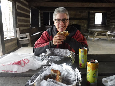

As delicious as those sandwiches were, they were also incredibly heavy. Not sure that was the best lunch to eat before climbing a mountain, but at least we weren't going to starve on the trail. 

We began our hike on Ziller Loop Trail:


Originally West Virginia was part of a great ocean and, over time, loose sand became sandstone, mud compacted to form shale and calcareous shells became limestone. Evidence of the uplifting and folding is all around. 

We began our climb upon Mt. Cacapon through a deciduous forest.


Cacapon Mountain takes its name from the Cacapon River (from the Native American meaning "medicine water") which empties into the Potomac River near the town of Great Cacapon. While the mountain is only 2,618 feet high, we had a 1,000 foot elevation gain in less than a mile.


There are no photos from our ascent, since we spent the time huffing and puffing. To celebrate reaching the summit, Kathy added a rock to the summit cairn.


The park map indicated there was a scenic overlook at the summit. As hard as we looked, we could not find the view.  A local hiker we encountered confirmed that, in fact, there is no scenic view because of tree growth the entire length of the ridge summit of Mt. Cacapon.


We decided to take the longer and less steep trail back down to the parking lot. We did get a view of the new resort lodge. If a more rustic stay is to your liking, you can still book the Old Inn, which was the original lodge built by the CCC.


Cacapon State Park is in the Ridge and Valley Province that was formed at the end of the Paleozoic Era by the horizontal pressure on the layers of sediment. All of the rocks in this area are sedimentary and it took 300 million years to create, fold and uplift them to their current form. Here Dave demonstrates how to show off your form.


As avid hikers, we have seen all sorts of trail blazes from simple cuts in a tree, to painted blazes in a myriad of colors, painted can lids and plastic circles. In all our hiking, this is the first time we've come across an exclamation point blaze. We wondered what it could mean, until we found ourselves looking down into a holler where the trail went straight down to the bottom.


While this was not our longest hike, we felt we got a good workout and needed a little refreshment when we returned to the trailhead. We made our first stop at Berkeley Spring Brewing. While the outdoor seating area was very nice, the brewery was filled with locals who glared at us for wearing masks when we entered the bar area to order our beers. We quickly quaffed our imperial stout and made our way to our second stop.


Cacapon Mountain Brewing Company was more our style. Located in an old mill building in downtown Berkeley Springs, the tap room was spacious and welcoming and they had several picnic tables outside where we could sip and relax.


We picked three styles to sample. The Fest beer was a standard octoberfest style. The porter was smooth and dark with just the right amount of sweetness. The Saison was light with lots of great belgian yeasty flavors. We couldn't decide which was our favorite, so we brought all three home.


We feel we only just scratched the surface of this area of West Virginia. Our next stop takes us further south in West Virginia to explore the new New River Gorge National Park. Stay tuned!

Bicycling the Chesapeake & Ohio Canal Trail from Paw Paw Tunnel

On Friday, October 22, 2021, we finally had a chance to get outdoors again after a lot of logistics.  Having moved to Gary's Cox Camping in Great Cacapon, in the far northeast hills of West Virginia, we decided to bicycle part of the Chesapeake & Ohio Rail Trail, which was accessible nearby in Paw Paw, West Virginia.  Here we are as we started the trail:


The rail trail has been formalized as the Chesapeake & Ohio Canal National Historic Park.  The Chesapeake and Ohio Canal operated from 1831 to 1924 along the Potomac River between Washington, D.C., and Cumberland, Maryland. It replaced the Potomac Canal, which shut down completely in 1828. The canal's principal cargo was coal from the Allegheny Mountains.  Construction on the 184.5-mile canal began in 1828 and ended in 1850.  It required the construction of 74 canal locks, 11 aqueducts to cross major streams, more than 240 culverts to cross smaller streams, and the 3,118 ft Paw Paw Tunnel. A planned section to the Ohio River at Pittsburgh was never built.

It turns out that our choice of Paw Paw to being our bike ride gave us a chance to explore the Paw Paw Tunnel, which was an important feature of the original canal.  The tunnel was built to bypass the Paw Paw Bends, a six-mile stretch of the Potomac River containing five horseshoe-shaped bends. The town of Paw Paw, the bends, and the tunnel take their name from the pawpaw trees that grow prolifically along nearby ridges.  The tunnel took more than 6 million bricks and 14 years to complete.  The tunnel was used by canal boats until the C&O closed in 1924. The tunnel and towpath are now maintained for public use as part of the Chesapeake and Ohio Canal National Historical Park. Though never one of the longest tunnels in the world, Paw Paw Tunnel remains one of the greatest engineering feats of its day.

It was only a half-mile ride to the tunnel, south-eastward along the canal path.  Even the entrance was impressive:


The tunnel is open to visitors.  Fortunately, the original towpath has been preserved and is a convenient walking path to explore the length of the tunnel without having to wade in the canal waters below:


The photo above gives you some idea of the tunnel's interior personality, but a photo alone is not enough.  In this video, Kathy demonstrates the proper method of hiking through a tunnel, and it captures the "spirit" of the tunnel more completely.

Unfortunately, the downstream end of the tunnel has been closed to bicycles and hikers because of a rockslide at that entrance.  We could walk from the upstream end, through the entire tunnel, but were stopped by fencing when we reached the far end:


Those who are brave enough, including those who want to pedal the entire canal path from Alexandria to Pittsburgh, can push their bicycles up (and down) a detour around the tunnel.  We, however, did not choose to do so, but simply turned upstream and set out on a 10-mile outing on the open bicycle path above the tunnel.

It wasn't long before we encountered what looked like a lock-keeper's residence near the Paw Paw Tunnel.  It now sits next to a picnic area and campground.  The campground is currently closed for the season, but we saw many picnickers in the open field by the historic residence.


The Baltimore & Ohio Railroad constructed a competing route along the Potomac River, right across the canal from the towpath.  As we pedaled further north from Paw Paw, we crossed under an old railroad bridge for that railroad:


The national park unit occupies the canal and railroad rights of way, but, on either side, there are numerous private properties.  It is clear, for example, that the strips of land between the canal and the Potomac River were farmed over the centuries.  Some fields are still farmed, and it appears that one property owner has rented out sections of that strip of land to hunters or fishermen to set up RV camps:


Most of the canal corridor is moist, giving opportunities for lush undergrowth.  It also nurtures a wide variety of fungi that feast on fallen trees:


As we reached our turnaround point, we crossed an old bridge that straddled a drainage for the canal.  It appeared that the bridge embraced doors that could be opened to empty the canal:


The drainage ran down to the Potomac River, and it invited us to follow it down to a gravel beach to see what views the river would provide us:

We decided to hike down to the Potomac River from the canal trail and saw this panorama.

After exploring the river beach, we crossed by foot back under the towpath, through the dry canal, and climbed an embankment up to the abandoned rail line.  We were curious about the condition of the railbed.  While the railbed was distinct and intact for the full length of our ride, sections have become overgrown, presenting obstacles to hikers and bikers who might be adventurous enough to explore the rail line.

We mounted our bikes for the ride back to our trailhead, and, as we rode, we noted a bridge on the far side of the Potomac that we had not seen on our ride out.  Kathy checked her GPS and confirmed that the bridge crosses the Little Cacapon River where it empties into the Potomac River:


We were happy that we had a chance to get out and stretch our legs after a week or so without our most enjoyable outdoor activity.  After another day or so, we hope to find a hike to add spice to this stay!

Monday, October 18, 2021

AT Hike from Ashby Gap to Rod Hollow Shelter

 Thursday, October 14, 2021

Hi Blog!

It took a couple days to recover from Birthday Weekend. With all our chores done, it was time to hit the trail again. As many of you know, one of our most favorite places to hike is along the Appalachian Trail. From our campground in Bull Run Region Park, we are only a short 45 minute drive away. For this hike, we decided to head back to the Ashby Gap. We had already hiked south from the gap. This time, we would be hiking north. There's not much of a trailhead - just a small "trail parking" sign and some blue blazes leading down the hill to the Appalachian Trail. So, here is our "trailhead" selfie!


In order to cross Highway 50/17 at Ashby Gap, the AT comes down off the ridge which means we needed to hike up to the ridge. The trail is rocky, so hiking boots are a must. Notice the "fun guys" peaking out from under the rocks.


The white blaze is synonymous with the Appalachian Trail. WhiteBlaze.net is a web site dedicated to AT thru hikers. The book White Blaze is a complete guide to the AT. No one knows for sure how many white blazes line the AT. The National Park Service estimates that there are over 165,000.


As we hiked along, the signs of fall were all around us. We are still several weeks away from peak color, but plenty of leaves were already on the ground. We noticed this little wooly bear caterpillar catching some rays on a sunny rock. Folklore says that the longer the woolly bear's black bands, the longer, colder, snowier, and more severe the winter will be. Similarly, the wider the middle brown band is associated with a milder upcoming winter. 


We were curious about the Myron Glaser Cabin. This section of the AT is maintained by the PATC (Potomac Appalachian Trail Club).  The PACT maintains 42 cabins to provide hiking and outdoor experiences for its members. Only 17 of these cabins are open to the public. These cabins extend from Charlottesville, Virginia through Maryland, West Virginia, and reach as far north as Shippensburg, Pennsylvania. Each cabin tells a unique, vibrant story; they were constructed by forest rangers, PATC members and benefactors, the Civilian Conservation Corps, and even Prohibition-era moonshiners. 


The Myron Glaser Cabin was donated anonymously, so we are not entire sure of its backstory. In 1978, the cabin was dedicated to the memory of Myron Glaser, a long time member of PATC and travel writer for the Washington Daily News.


This area was settled in the early 1800s. From 1861 to 1864, the Ashby Gap area saw several different battles during the Civil War. We couldn't determine is this was an old farm fence or a Civil War barricade, or perhaps both. The trail travels right through the stone wall.


We don't often encounter actual stairs on the AT, but when we do, we give thanks to the hard working trail crew that installed them.


Boardwalks are also fun to find, especially through wet and marshy areas.


We thought the Rod Hollow Shelter would make a nice lunch stop. The blue blazed side trail to the shelter was well marked.


The Rod Hollow Shelter was constructed by volunteers from the Potomac Appalachian Trail Club in the summer of 1985. It is located several miles north of Paris, Virginia and is the last stop before the "rollercoaster" section of the AT in Northern Virginia. One unique feature of this shelter is the double decker sleeping platform.


We enjoyed our lunch under the covered picnic shelter. There were no other hikers around since the folks who stayed the night had packed out already, and those using the shelter this night had not yet arrived.


We've seen some unusual things along the trail, but none as strange as the Osage Orange. Maclura pomifera, commonly known as the Osage orange, horse apple, hedge, or hedge apple tree is a small deciduous tree or large shrub. The distinctive fruit is round, bumpy, 3 to 6 inches in diameter, and turns bright yellow-green in the fall. Despite the name Osage Orange, it is not related to the orange. It is a member of the mulberry family. It has also been referred to as monkey ball, monkey brains, yellow-wood and mock orange.


After lunch, we hiked back up to the AT. Dave checked the trail marker to make sure we are headed in the correct direction. The next shelter southbound is the Whiskey Hollow Shelter, which is nine miles away. Luckily for us, our Jeep was parked only four miles away.

On our way back to the trailhead, we ran into several section hikers who stayed the night at Whiskey Hollow and were making their way to Rod Hollow Shelter. They were very excited to know that the shelter was large, clean and had a well maintained privy, complete with toilet paper! 

When thru-hiking, it's the little things that matter.

Wednesday, October 13, 2021

Bicycling in Bull Run Regional Park - Discovering the Harris Cemetery and Manumitted Slaves

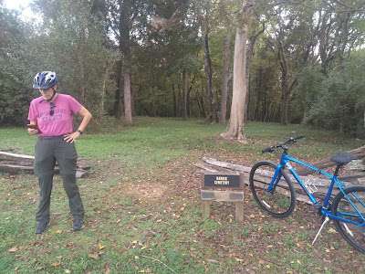
When we were bicycling around Bull Run Regional Park today, we found a plot of ground, bordered by a wooden split rail fence, with a sign identifying it as the "Harris Cemetery."  Not knowing what it was, Kathy whipped out her trusty Google device and searched --

-- finding a web page of the Fairfax County Park Authority titled, "A Little-known African American Community at Bull Run" which reads in full as follows:


“… I have for some time past been convinced that to retain them in Slavery is contrary to the true principles of Religion & justice, & that therefore it was my duty to manumit them…”.

So wrote Robert Carter III in his Deed of Gift on August 1, 1791. Carter, one of Virginia’s wealthiest landowners, arranged to manumit the 452 people enslaved on his twelve farms, including the 809-acre Leo farm that spanned Fairfax, Loudoun and Prince William counties. Some of the 43 women, men and children emancipated from Leo farm would establish a small community in Fairfax County south of Centreville between Bull Run and Cub Run. Over the next 200 years their settlement would thrive, becoming one of the largest African American communities in Fairfax County.

Nathaniel Harris, Uriah Amager and their 18 family members settled north of Bull Run before 1810. By 1820, 12 households including the Harrises, Burkes, Paynes, Amagers and Clarks also established farms in the area and the population had grown to 52. Jesse Harris purchased the 211-acre “Waterside” tract in 1844. By 1859, the Harris family alone owned over 570 acres. As early as 1854, local families founded the Cub Run Primitive Baptist Church, which still stands on Compton Road. Throughout the next decades, all families were engaged in agriculture, producing primarily wheat and corn, and supporting local merchant mills and stores. Many were related to James Robinson, a free African American whose farm site is now preserved at Manassas National Battlefield Park.

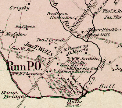
The free African American farmers above Bull Run were not spared when the Centreville region became a battleground during 1861-1862. Confederate and Union Armies repeatedly destroyed property and requisitioned crops and animals. After the war, Jesse and Obed Harris filed claims with the Federal government. Each received compensation for property that Union forces had taken in 1862. Families resumed life and slowly regained economic footing. In February 1868, Charles Harris successfully appealed to the Freedmen’s Bureau for $150 to complete a school for local children. The Rock Hill “Schl Ho” sits among the Harris, Naylor, Jordan and other homesteads that comprised the community in 1879, as seen on G. M. Hopkins’ map of Centreville District No. 1, Fairfax County (detail, Library of Congress).

Historical cemeteries and the Cub Run Primitive Baptist Church are among the few known physical remnants of the African American community that once flourished at Bull Run. Nonetheless, many proud descendants of families who established and once resided there enthusiastically research and share information that sheds light on their ancestors.

Author Heather Hembrey is the Assistant Collections Manager for the Archaeology and Collections Branch. Her research is used to inform the archaeological work done throughout the county.

-0-0-

It was fascinating to learn that free Black persons formed a community in the area, but it was doubly interesting to find, when we examined the map in the photo above, that virtually all of Bull Run Regional Park sits on land formerly owned by members of that community.  All we had previously known about the park's history was that it saw quite a bit of action during the Civil War, most notably at Blackburn’s Ford, where a federal brigade attempted to cross, but Confederate fire forced Union commanders to cross the creek farther upstream. The site of Blackburn's Ford is visible just a short walk down the Occoquan Trail along the creek, near the crossing of modern day Route 28.  In addition, the 19.6 mile Bull Run Occoquan Trail served over the years as part of a system of Native American trails, trade routes, and later as civil war supply routes.

Leaving our bicycles and walking into the cemetery,  we found that an area within the fencing has been mowed from time to time, but is fairly rough ground.  Rough unengraved stones mark some of the graves.  

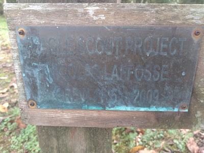
A closer examination of the sign at the front of the cemetery --


-- reveals that a certain Andrew LaFosse led a crew to clean up the cemetery (and possibly uncover and reset headstones) in 2009 and 2012, as part of a Scout project.  We tried to find information about that project, but were unsuccessful, so poor Andrew's work will have to get only this much credit.

All of this is to show that you never know what interesting history you'll find when you turn the next corner!

Tuesday, October 12, 2021

Camp Sharktooth Birthday Celebration 2021

Finally, it's here!  Birthday Weekend and the Awards Ceremony for Camp Sharktooth 2021!

William and his Mom and Dad, and Gugu Katie were all to converge on our RV for a birthday party on Saturday, October 9, before Katie had to jet off for a wedding in Kansas City.  We made all the preparations, including a BIG "Happy Birthday William!" with the Camp Sharktooth logo:


Weina had purchased the birthday decorations themselves, and she, Matt and William set about hanging them as soon as they arrived:


We had pumpkins for carving, and everyone exercised maximum creativity.  Our final works were displayed by the RV.  Weina's and William's got the award for Scariest Design of a Jack O'Lantern.  Kathy got Most Classic Jack O'Lantern.  Matt got the award for Most Bubu-Like Jack O'Lantern (complete with tongue hanging out one side of its mouth).  Katie got Most Emoji-Like Jack O'Lantern.  David got Most Picasso-Like Jack O'Lantern.  This was the most awarded pumpkin carving contest ever.


In addition to being the celebration of Matt's and William's birthdays, it was also the occasion for William's graduation ceremony for Camp Sharktooth - The Second Year.  Kathy pulled out a Camp Sharktooth Lanyard with lots of pins representing William's activities and achievements and presented them to the group for admiring --


-- then presented William with the lanyard and invested him with it:


From there, we didn't hesitate to jump right into a campfire dinner and birthday cake -- William's favorite selection of Red Velvet with butter cream icing.  

And of course there were presents.  William scored some great ones, including these spirit stones from Gugu, which William loved:


Gugu jetted off Sunday morning, and we puppysat for puppies Beth and Ruthie.  We had lots of pawful adventures the whole day.  William volunteered to sleep overnight at Gugu's hotel room to help David keep the puppers company.  Here, the whole crew gets settled for the evening with a movie called (appropriately enough), "Dog Gone Trouble":


Then it was time for bed.  David and William signed off with a sleepytime selfy to send to Weina, Matt, Kathy and Katie:

Good night, everyone, and HAPPY BIRTHDAY MATT AND WILLIAM!