Search This Blog

Sunday, April 21, 2024

Crowley's Ridge State Park

On April 19, 2024, we had one layover day at our campground in Crowley's Ridge State Park, near Paragould, Arkansas, and discovered that Crowley's Ridge -- which we were sitting on! -- has great geological and human interest.  So we decided to devote the day to exploring what was around and under us.

We started by visiting the Crowley's Ridge Nature Center in nearby Jonesboro, which tells all there is to know about this place:

The visitor center is an attractive building designed to be compatible with its environment:

The lobby, with its large, immersive diorama, immediately draws a visitor into the landscape it introduces:

The center focuses on the flora, fauna and geology of Crowley's Ridge.  In addition to many stuffed animals representing local species, it also houses live animals such as local freshwater fish and this cute little owl who looked at us expectantly, hoping we were bringing him his overdue lunch.  He gave us this little look that reminded us of our cat Ruby, trying to communicate without human language:

Some of the animals were not so alive, such as this skeleton of a snapping turtle --

 -- and this stuffed turkey:

The exhibits were well curated and clearly had in mind the interests of school classes on field trips.  There was a demonstration hall with numerous round tables for kids to sit at while learning about the animals presented in the demonstrations.

The primary reason for our visit to the nature center was to learn about the geology and history of Crowley's Ridge.  It turned out to be far more interesting than we expected.

Crowley's Ridge is a geological formation that rises 250 to 550 feet above the alluvial plain of the Mississippi for a 150-miles from just west of Cairo, Illinois, south to the Mississippi River near Helena, Arkansas.  It ranges from 1 to 12 miles wide.  Interesting, its origin, though originally thought clear, is now in dispute.  Originally, geologists thought that it was formed by glacial sediment, known as loess, that was deposited in the area when this ground had been under a great sea that has shrunk to become the Mississippi River.  Originally, scientists thought that the loess was pressed by overlaying sediments, and then, as the sea receded, formed by erosion action of the Mississippi River on its west and the original course of the Ohio River on its east, both flowing south.  At some point, the Mississippi River changed course and joined the channel of the Ohio River, causing the upper Ohio River to become a tributary of the now doubled Mississippi River.  This left Crowley's Ridge standing west of the Mississippi, where it no longer felt the river's erosive effects and has stood since.  More recent scientific thinking suggests that Crowley's Ridge was simply formed by volcanic or seismic uplift, which itself may also have changed the Mississippi's course.  In either event, Crowley's Ridge stands in stark contrast to the Midwest Prairie to its west and the Mississippi Delta to its east -- both flat as pancakes.

Prior to its isolation, Crowley's Ridge had been part of the same mountain system as today's Appalachians, rather than the Ozark Mountains to the south.  Thus, the vegetation is predominantly oak and hickory forests, similar to vegetation found in the Appalachian Mountains. Examples are the tulip tree (or yellow poplar) and the American beech. Ferns and flowers abound here, including the American bellflower, fire pink, butterfly weed, cardinal flower, blue lobelia, phlox, verbena, wild hydrangea, hibiscus, aster, and yellow jasmine.  We saw examples of many of these around our campground and during our later walk around the park.

After visiting the nature center, we stopped at Native Brew Works, a remarkable brewpub, organized as a member club due to the restrictive Arkansas liquor laws.  Alcohol can only be served in limited quantities, and only on premises along with food.  Customers become "members."  As it turned out, the wide variety of their own beers on tap were excellent examples of their various styles and quite tasty -- limited to 5% or lower ABV by Arkansas law.  The food menu was limited but extraordinarily tasty and quite unique.  We enjoyed lunch so much that we posted a photo of the food and drink at the end of this blog entry!

Thus quaffed and fed, we repaired back to Crowley's Ridge State Park, armed with our newfound knowledge of its geology and flora.  We took a 2-mile stroll around the park to see its most notable sights, including the small but pretty Lake Ponder:

The steps down to the lake shown in the photo above, together with other improvements that we saw, were constructed in the 1930's by the Civilian Conservation Corps (CCC).  

We always enjoy visiting state and national parks that benefited from the CCC's work because so much of it has stood the test of time and remains remarkable in its architecture, beauty, strength and durability.  It was a voluntary government work relief program that ran from 1933 to 1942 for unemployed, unmarried men ages 17–28. The CCC was a major part of President Franklin D. Roosevelt's New Deal that supplied manual labor jobs related to the conservation and development of natural resources in rural lands owned by federal, state, and local governments.

By the time the CCC program ended at the start of World War II, Roosevelt’s “Tree Army” had planted more than 3.5 billion trees on land made barren from fires, natural erosion, intensive agriculture or lumbering. It was responsible for over half the reforestation, public and private, done in the nation’s history.  CCC companies contributed to an impressive number of state and national park structures that visitors can still enjoy today. More than 700 new state parks were established through the CCC program.  It became a model for future conservation programs. More than 100 present-day corps programs operate on its model at local, state, and national levels engaging young adults in community service and conservation activities. 

Crowley's Ridge State Park preserves a large number of unique CCC structures.  Some, such as a footbridge, have disappeared, but most remain, including a CCC Overlook --

-- that provides a view of Lake Ponder ---

-- and its denizens, including these goose parents and their three fetching goslings --

-- a 600 seat amphitheater that has since lost two-thirds of its original 2,300 seats --

-- a large pavilion built of cypress wood --

-- with a huge seating area and a separate dance floor --

-- and even chandeliers carved from cypress knees! --

-- not to mention a number of cabins, only one of which survives today and is available for rental for overnight stays:

This was quite a walk through architectural and park history.  Together with our trip through geologic history in the morning and our very memorable lunch --

-- this casual, impromptu outing on a stop of convenience may just have become one of most memorable of our last stays in this about-to-end full-time RV career.  

We only wish that you might have as many unexpected pleasures in whatever adventures you are pursuing!

Wednesday, April 17, 2024

Back to The Crater of Diamonds

April 15-17, 2024

Hi Blog!

We're back! It's been two years, but we finally made it back to the Arkansas Crater of Diamonds State Park. We first visited the park in April 2022 and did a lot of digging and collected gravels to take home. Click the link to our prior blog for all the history and background on the process. We did bring back some possible diamonds for the park geologist to examine. Unfortunately, they turned our to be quartz and amethyst. However, hope springs eternal and we returned to the field to try our luck one last time.

For this visit, we made arrangements with Lovejoy Diamonds to rent a wagon complete with screens, shovels and buckets. While you can rent equipment from the State Park, they only have a few wagons. By renting ahead of time, we could leave the Jeep in the campground and pull the wagon over to the search field with all our stuff.


Rather than use the public wash stations, we decided to use our wagon to wash our gravel. There were several other miners using the spigot, but they brought a splitter, so we could attach our hose without bothering their operation.


The screens come in two sizes. The smaller top screen has large mesh which allows the smaller gravel to pass through. The larger screen has finer mess and holds the small gravel which the diamonds like to hide in. The fine gravel is then transferred to the round saruca which allows the heavy minerals like quartz and diamonds to be concentrated in the center. We scoop out the centers to take home with us.


After cleaning out four 5-gallon buckets, we had filled our 2 gallon bucket with fine, sifted gravel to take home. We took a break for lunch and then decided to stretch our legs by doing a little surface searching. When the sun is bright, it is possible to find diamonds just laying out in the field.


As the day progressed, more and more folks visited the wash station. We were glad we had our own setup to wash our gravel.


However, these Craterheads made us look like pikers. Their four-person team processed dozens and dozens of buckets of gravel.


Most of the pictures we took were from Monday. Thunderstorms were predicted for Tuesday. A heavy rain can wash diamonds from the gravel, making them easier to spot on the surface. Unfortunately, we never really got the rain they predicted. When we returned to the park on Wednesday, it was pretty much the way it was on Monday.

We ended up not staying as long on Wednesday. Lifting buckets of gravel and pulling wagons filled with gear is hard work. Once we returned to camp, it was time to clean up. We ended up taking a shower in the campground bathhouse with our pants on!

.

Crater of Diamonds is a unique experience. While it can be very physical, it is also fun sharing the experience with fellow treasure hunters. 

We have TWO 2-gallon buckets of stones and gravel to take home. Once we get a chance to clean and dry it, we'll let you know if we find any treasure! Stay tuned.


Sunday, April 14, 2024

Twenty Leaps on Trail Between the Lakes

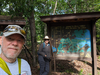
We're on our way home!  After enjoying the Great American Eclipse in Uvalde, Texas, and joining our friends Kim and Jane in San Antonio, we took another step north to Sam Rayburn Lake in Brookeland, Texas.  We had one day - Saturday, April 13, 2024 - to explore and decided to hike the Trail Between the Lakes:

 
The Trail Between the Lakes winds through the Sabine National Forest, connecting Lake Sam Rayburn and Toledo Bend Reservoir. The well-marked, 28-mile trail, which runs from US Hwy 96 in sight of Sam Rayburn to the Lakeview Recreation Area on Toledo Bend, wanders through pine and hardwood forests, up and down East Texas’ gentle hills, across lovely stream corridors, and along Lake Toledo Bend. The trail crosses roads at a number of locations, providing access to shorter hikes. 
 
Sabine National Forest covers a total of 160,873 acres in five counties of Texas. It includes the officially designated Indian Mounds Wilderness, which is a part of the National Wilderness Preservation System. The Sabine National Forest is notable for extensive forests of American beech and other hardwood trees. Other important tree species include loblolly pine, longleaf pine, shortleaf pine, white oak, southern red oak, sweetgum, and Florida maple.  The Civilian Conservation Corps (CCC) helped the Texas Forest Service develop the forest between 1933 and 1940. CCC Company 893 established camp near Pineland, Texas on June 14, 1933, and planted pine seedlings in the southern part of the forest. These men also built roads and fire lookout towers and completed the Red Hills Lake Recreation Area near Toledo Bend Reservoir. CCC Company 880 established camp near Center, Texas on October 26, 1933, and planted thousands of pine trees in an area that became the northern part of Sabine National Forest. The CCC built the Boles Field Campground, including a pavilion and amphitheater, in the forest near Shelbyville, Texas. 

We started at the western end of the trail, near Sam Rayburn Lake, and decided to walk three miles into the trail, and then three miles back to our point of beginning.  It was a small sample of the whole trail, but it gave us a great introduction to the ecology of Sabine National Forest.

That ecology includes fungi as well as more traditional plants:

About a mile into the hike, we crossed a railroad track as we followed a forest road from one section of foot trail to another:

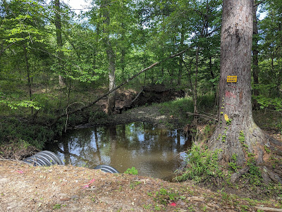
Our route along the forest road was perhaps half a mile.  It led us downhill from the upland section where we started, into a lower area laced by drainages.  We began to realize that this would be a hike of leaps across small streams and drainages as much as it was a hike across dry terrain.

As we worked our way down the road section, we saw that the forest crew was busy clearing drainages along the road, renewing culverts, and installing concrete portals for the streams crossing under the road:

At this stream crossing, the culverts looked newly installed, but -- still -- the stream seemed to be almost too much for them:

It is early spring, and we spotted a few wildflowers along the path:

The leaves are out, and, in some places, they create a bower-like effect, which offered shade that we both enjoyed:

Recent storms that had marched across the U.S. left wet sections on the trail.  They were easy to navigate, but they added needed moisture to the forest floor and gave us an unusual view of the woods:

In addition to mushrooms and other more common fungi, we spotted these unusual little red ball-like fungus growths on the trunk of one of the pine trees:

This hole with sculpted mud around it offered us a mystery.  Who was the resident?  It turned out that the ground was so damp that CRAWFISH have found the opportunity to make little tiny houses.  Who would have thought?

It was indeed damp enough that moss was growing on the shady side of trees and stumps, and we were lucky enough to see some rich samples:

 Indeed, this area, being laced with streams and drainages, offered us TEN stream crossings!  They were each small enough to leap with an easy hop, so we were not hampered.  But this may have been the most stream crossings we've had in a single day hike:  Twenty!

As we were finishing our hike, Kathy spotted this tree.  It is marked as a "bearing tree," in addition to having a blaze and other markings on it.  As a bearing tree, it is used in the survey description for boundaries of various tracts in the Sabine National Forest.  Based on this and the work along the forest road, we concluded that this forest is very well managed.

We only had one day in northwest Texas before heading on to Crater of Diamonds State Park in Arkansas, but we made the most of it.  The next time you hear from us, we will have something to say about diamonds!


Thursday, April 11, 2024

Two Days in San Antonio - Eclipse Epilogue

April 10-11, 2024

Hi Blog!

On Wednesday, April 10th, we said our final goodbyes to Eric and Ginny as they pulled out of Chalk Bluff ahead of us. Despite the cloudy weather, a good time was had by all.

After leaving Uvalde, we made our way to San Antonio to meet up with Jane and Kim one last time before they fly back to the UK. While we were busy moving our RV, Jane and Kim were busy visiting the Spanish Missions around San Antonio. Since we had already visited the missions, including the Alamo, we decided to meet them at the Grotto along the San Antonio River Walk.


While we waited we watched this Momma duck try to get all her ducklings in a row.


The turtles, on the other hand, had no problem lining up.


The Riverwalk Grotto was created by Carlos Cortés. This fantastical grotto is filled with craggy faces carved into cave-like walls, splashing waterfalls and surrealistic, winding passageways with eerily realistic stalagmites and stalactites. The three-story, dream-like sculpted structure is located in a bend of the river between the Camden and Newell Street bridges.


We no sooner found a bench to wait when Jane and Kim arrived. Timing in life is everything.


After some interesting photos of the grotto, we decided to head over to the Pearl District for a pint. This section of the Riverwalk was expanded in 2008 to include five small waterfalls.


Located just north of downtown San Antonio, the Pearl District provides a unique experience as a top culinary and cultural destination. The former Pearl Brewery buildings contain mixed-use space featuring retail, dining, green spaces, a riverside amphitheater, and the campus of The Culinary Institute of America. The Pearl is filled with food and drink options, boutique shopping, festive seasonal events and loads of local flavor. While the Pearl is no longer an active brewery, Southerleigh still makes craft beer. Cheers!


After strolling through the Pearl, it was time for Jane and Kim to hit the road. We joined them for a farewell dinner at a local Thai Restaurant before they drove off to Houston. We look forward to when our paths cross again!

Now that everyone has gone their separate ways, it's time for us to get back to our normal RV schedule. The San Antonio KOA where we are camped is located right along a portion of the San Antonio Greenways. We were eager to take the bikes out for a spin.


The Greenway Trail System is a growing network of 101 miles of developed multi-use trails. The portion we rode was along the Salado Creek. The recent thunderstorms muddied the creek. We could see evidence that the creek left its banks and swept across the trail.


The idea to build the Greenways was spearheaded by former Mayor Howard W. Peak.  His dream was to build a "ring” of hike and bike trails along creeks around the City of San Antonio. This idea quickly became a shared vision among city leaders. Funding for the Greenways was first approved by voters in 2000, followed by three subsequent elections, to use 1/8 cent from local sales tax revenue to develop the trails. Current funding is being used to expand the trail system and to enhance the existing trails. We loved seeing all the wildflowers and butterflies along the trail.


There are a number of neighborhoods along Salado Creek. Each one has its own park. We were impressed by the smoker and large fans in this neighborhood picnic area.


Our section of the Greenways Trail ended at the Southside Lions Park. The 600 acre park was purchased by the City in 1944 to be used as a garbage dump. Residents and members of the Lions Club successfully petitioned the City to use the land as a park. 

Fanciful flower sculptures surround the Greenways Trailhead.


Rather than just turn around and head back, we decided to ride around the 10 acre lake. This snowy egret was busy fishing and didn't seem to mind us stopping to watch.


However, these ducks were giving us the side-eye as we approached.


As we circled the lake, there were several fishermen sitting in their favorite spots hoping to try their luck.


The trail went right by a tiny race track. We later learned it was owned and operated by the Lone Star Quarter Midget Association. Quarter midget racing is a form of automobile racing. The cars are approximately one-quarter (1/4) the size of a full-size midget car. The kids range in age from 5 to 17. The cars look like go-carts with a cage around them.


As the morning warmed up, the caterpillars became very active. We spent most of the ride back to camp trying not to run them over. 


Tomorrow we move to Brookeland, Texas. We are slowly working our way back to Pennsylvania. We have a few more stops and hope to have a few more adventures, so stay tuned!