Search This Blog

Friday, September 30, 2022

Biking the Perkiomen Trail South

Almost two weeks ago, we pedaled the 10 mile northern segment of the Perkiomen Trail.  Today was the day to put our wheels on the 10-mile southern end of the trail.

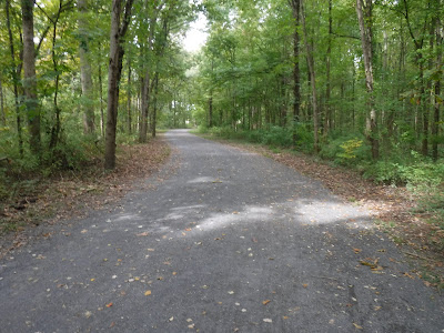
Our total mileage today was almost 22 miles as we included part of the Audubon Loop Trail at the southern end.  Fall was clearly showing on the trail:

The Audubon Loop Trail encircles the John James Audubon Center at Mill Grove, which we plan to visit in the near future, so we won't spend much time discussing that facility, except to say that the ground are impressive.  Mill Grove was the location where Audubon first developed his famous method of depicting birds and other wildlife.  

The Audubon Loop Trail passes some other interesting sites, including Martha's Community Farm, recently launched by Martha’s Choice Marketplace, a ministry of Catholic Social Services of the Archdiocese of Philadelphia.  The farm, located on the grounds of the former Saint Gabriel’s Hall in Audubon, Pennsylvania, grows produce, flowers, and herbs to benefit individuals and households served by Martha’s Choice Marketplace. Items grown also support Martha’s Choice Marketplace’s network of food pantries throughout Montgomery County.

Directly across the street is the old Saint Gabriel's Hall, operated by the De La Salle Christian Brothers, which has closed.  It housed a residential and educational program for Philadelphia youths ages 13 to 19 whose situations were determined by the courts; the Mitchell Program, a 120-day residential treatment program; and De La Salle Vocational (DelVoc), a treatment center and educational program based in Bensalem.

 
Further on, we approached the Audubon Society wildlife preserve itself, riding along the edge of a small meadow demonstrating how naturalized environments support an abundance of wildlife:

After passing the Audubon Center itself, we came up alongside the smokestack of the powerhouse that operated the copper mine operation at Mill Grove:

After something over a mile, we reached the Perkiomen Trail itself, here in the community of Oaks, Pennsylvania.  At the first bridge, we had a beautiful view of Perkiomen Creek -- one of many along the trail, which runs beside the creek:

A variety of bird life inhabits the waterway, including herons --

-- geese, egrets, hawks, and, we're sure, many other species we didn't spot.  At a number of spots, the termini of old roads have been redeveloped as fishing docks for the locals:

Some property owners along Perkiomen Creek are lucky enough to have small docks where they can store paddle craft.  On our peddle, we spotted a number of fishermen casting from kayaks to undercut banks that would otherwise be unreachable.

The Perkiomen Creek suffered a major flood in early September 2021, with waters reaching an unprecedented height of over 26 feet.  Along one section of the creek, where the western bank was walled by a dark stone cliff, properties on the eastern bank were inundated when the waters had nowhere to flow.  This property still shows the sad, empty foundation and deck of a house that was wiped away by the flood:

The flood prompted a wide variety of reclamation projects, including regrading banks, riprap of banks and other augmentation with stone and concrete, as well as safety fences along the trail to protect users from unsafe cliffs:

Further along, we were surprised to run across a number of fallen breadfruit, which is the fruit of a species of flowering tree in the mulberry and jackfruit family.  It is believed to have originated in New Guinea, the Maluku Islands, and the Philippines. It was spread to other tropical regions of the world during the Colonial Era and apparently has also now been propogated in Pennsylvania.

Another marvel of nature was to appear to us not a lot further on, when we rode by a Swamp White Oak, over 80 feet tall, which is said to have been alive since 1694, making it 328 years old!  Below, Kathy inspects the tree and reviews the information about it on a trailside marker:

This trail just kept on giving to us.  Again, it wasn't long after leaving Collegeville that we came across a miniature steam train exhibit by the Pennsylvania Live Steamers, a volunteer group established in 1946 and dedicated to the preservation of the nation’s rich mechanical and engineering heritage. The group's purpose is to formulate and carry out plans for the construction and operation of a live steam railroad and to foster a spirit of cooperation among live steam railroaders.  The 5-acre club site has 3,200 feet of 1½″ scale (7¼″ gauge) track, 3,000 feet of 1″ scale (4¾″ gauge) track, an 800-foot multi-gauge track loop and a 219-foot dual-tracked Gauge-1 loop. There are multiple unloading facilities.

The trail weaves back and forth across Perkiomen Creek, with a variety of architecture visible along its banks:

One trail bridge is an old railroad bridge which has been stabilized and repurposed for mutli-use recreation:

A number of small creeks empty into the Perkiomen, including this picturesque Schoolhouse Run:

We were nearing our turnaround point at 11 miles, and we were both getting hungry.  As we reached a wetland with numerous cattails, Kathy may have mistaken this punk-on-a-stick for a corn dog in her famished state:

Luckily, she came to her senses.  In another mile or so, we reached a trailhead and were able to wolf down lunch and some dessert of pears and apples.  After a rest and rehydration, we were ready to peddle back south to our point of beginning.  Luckily, the trail was mostly downhill on the way back, so our return ride was easier than the ride upstream.

We're tired and our legs are a little sore, but this has whetted our appetite for more rails-to-trails adventures -- of which there are many in Southeastern Pennsylvania.  We have to sit down and map out some more of these trips!

Stay active, my friends.

Wednesday, September 28, 2022

Nockamixon Hike with the DVAMC

Wednesday, September 28, 2022

Hi Blog!

When the kids were little, it was a family tradition to go car camping and hiking over Memorial Day Weekend. We stayed in the same campground and hike the same trails each year. As the kids grew and went off to school and jobs, we transitioned from car camping to backpacking. We had joined the Delaware Valley Chapter of the Appalachian Mountain Club. We went on numerous club hikes and backpacks. We took all of the outdoor classes offered at the Mohican Outdoor Center, including Wildnerness First Aid, Map & Compass, and even Introduction to Winter Backpacking (brrrr). It didn't take long before we took the Leadership Training Course and began leading hikes. We enjoyed our involvement with AMC, but the open road was calling.

One of the reasons we became full-time RVers was the long drives (and plane flights) back from our hiking and backpacking adventures. On one of those long trips home from the mountains, we thought: Wouldn't it be nice if our house were parked at the trailhead? We could come right off the trail and take a shower and have dinner without getting stiff on that long ride or flight home. Thus began a five year plan to buy an RV, sell our house and hit the road.

We've been on the road now for 11 years. While we have been back in the Philly area each year, we were never here long enough to participate in any DVAMC outings. We have a week or so before we are scheduled to puppy sit again, so we logged on to the DVAMC Activity schedule and found a hike at Lake Nockamixon State Park. We had recently hiked a section of the park and were looking forward to discovering another section.

We meet our fellow hikers at the Kellers Church Road Trailhead. The weather was perfect and folks came out in droves. Once everyone signed in and counted off, there were 29 of us! At the beginning of every AMC hike, folks circle up and introduce themselves and mention were they are from. We actually encountered folks we hadn't seen in 11 years! We had a great time catching up.


The hike connected several different trails for a total of 8 miles. Group hiking is a social event. We answered lots of questions about full-time RVing. However, we also learned of new trails and paddle opportunities in the area. Unfortunately, all that gabbing left little time for photos. However, we did make a number of side trips. We used this dry stream bed to make our way to the lake shore.


It didn't take Kathy long to grill a fellow hiker on the fishing opportunities in the lake.


The weather was perfect for sailing.


After a quick snack and drink, it was back on the trail. The folks we hiked with were well traveled. Some were planning a trip to Nepal. Others were heading to New York, while still others were planning to head down to Chincoteague.  One of our fellow hikers is even planning a trip to hike the East Coast Trail in Newfoundland, which is what we plan to do when we take our RV to Newfoundland next year.  It turns out the hiker grew up on the West Coast of Newfoundland and is very familiar with places in that part of the province, such as Gros Morne, that we enjoyed so much when we visited The Rock in 2018.  It was much fun comparing notes with her about that wild and wonderful Maritime place.
 
After five miles, it was lunch time.


An old dock made a convenient picnic spot.


A anhinga also found a convenient place to rest nearby.


As we dug into our packs, a couple of kayakers passed by.


As we prepared to hit the trail again, we looked back to take in the lake. The recent cold nights are starting to bring out the fall colors.


As we switched from one trail to the next, we passed an historic house, which appeared as if it might be ranger housing:


While Nockamixon doesn't have a campground, it does boast several cabins for rental.  

There is an interesting ropes course that groups use for team building exercises.  The activity center for the ropes course was near our lunch spot --


-- as was the ropes course itself:


The climbing town was impressive:


With all our socializing, the last few miles passed quickly. Now you might think this was the end of the adventure, but there was one more stop to make.

Hike leaders often have their favorite places for post hike recovery. Some prefer brew pubs, while others go all in for ice cream. Today's post hike stop was Owowcow (O Wow Cow) for hand crafted ice cream. We decided to order milkshakes - Dave went with blueberry lemon, while Kathy picked banana chocolate chip.

Of course, even ice cream cannot be consumed by AMC hikers without a heavy portion of conversation, so we flavored our shakes with the spice of sociability.  We had a great time socializing with fellow hikers and look forward to getting out on another hike before we leave the area.

Sunday, September 25, 2022

Skippack Creek Loop Trail - Again After Eight Years

It was November 2014 when we last hiked the Skippack Creek Loop Trail.  We were camped in Hatfield, Pennsylvania as we are now (but not the same campground), and we had the Fifth Wheel and Freightliner truck.  Last time, the leaves had turned into a riot of color, and many trees were entirely bare --

-- but this time, as we started our hike, there was lush green everywhere:

We were surprised to see as many wading birds as we did.  We spotted at least two heron and two egret during the hike:


The fungi were equally prevalent --

-- especially this Jack O'Lantern Mushroom (Omphalotus olearius), which the small tag in the mushroom noted is "Poisonous!" and that it glows GREEN at night.  Fascinating!

Then there was this tree fungus with some strange-looking symbiotic friend perched atop:

But the trail itself was interesting.  There were some crooked bridges that threw Dave askew --

-- and some quarries where we learned that brownstone (another name for hard brown sandstone) was cut from the cliffside and shipped for building construction all along the East Coast from the mid-1800's to 1915.  Here, someone had pulled out some loose blocks, leaving an intriguing hollow in the cliffside:

The signage was quite good, new looking, and most of the bridges looked newly built:

We only learned afterward that the entire Schuylkill Valley suffered heavy flooding in 2021 from Hurricane Ida, which washed out most of the bridges in the area.  This is the sedate view today from one of the new bridges over Skippack Creek on Kratz Road:

There are two or three historic houses along the trail, which appear to be grandfathered and in private hands.  One, however, is part of the park and is known as the Friedt Visitor Center, which, together with its herb garden and root cellar, calls forth the ambience of early colonial farmsteads.  This historic farmhouse was built in the early 1700s and now interprets the lifestyles of the German Mennonite families who owned the home for 190 years:

Some sections of the park, which had obviously been farm fields historically, now present themselves as beautiful meadow, growing colorful this Fall season:

On the far side of the creek, as we worked our way back upstream, we encountered an unassuming amphitheater set alongside the creek, presumably for schoolchildren and other guests of the Evansburg State Park Visitor Center to learn more about the park, its history and its ecology:

During 1684, when William Penn purchased the portion of his American Province that is now Evansburg State Park, the inhabitants were the Unami of the Lenni Lenape Nation. Shortly thereafter, the area was settled according to the plan of Penn’s “Holy Experiment.”  The area developed rapidly. By 1714, the Skippack Pike was constructed to provide access to the Philadelphia market. The Skippack Valley remained an agrarian economy through the early part of the twentieth century. Following World War II, the pace of change quickened. Prior to acquisition of park lands, the rural charm of the area was in danger because much of the countryside was being threatened by urbanization.  During the late 1960s, 3,349 acres were acquired for the present Evansburg State Park, which officially opened for public use in 1979.

Before long, we had passed the 4-mile mark and were getting ready to cross this relatively new non-vehicle bridge at the south end of our hike, an extension of Mill Road.  As we approached the bridge, a large group of cyclists crossed the bridge and headed on up to the West behind us:

On one of the rails of the bridge, we spotted this bird's nest, which someone had probably found on the ground and rescued for the benefit of passersby like us:

But we've saved the most unusual for last.  In our hike of this trail in 2014, we happened upon these ruins of what might have been a mill.  Kathy climbed the step-like structure --

-- but when we returned this time, the top steps had crumbled away, possibly in the flooding from Hurricane Ida in 2021.  But we noticed that the graffiti had been refreshed since our first visit.

We tried again this time to research what the ruins might have been, but were unsuccessful, so they will remain a mystery.  Perhaps next time, we'll ask at the Visitor Center to see if any of the staff knows anything about those ruins. 

Go Eagles!